
Apr 19, 2024
Apr 19, 2024
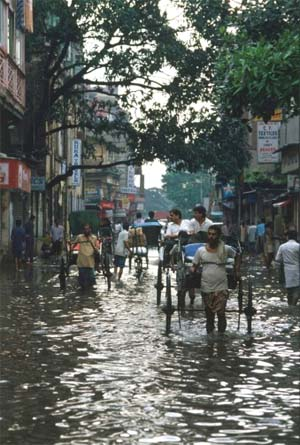 Come monsoon and the newspapers are full of predictions of a good or bad monsoon. Being an agro-economy our country depends much upon the rainfall. Excess rains lead to floods and both urban and rural habitats face the fury of the rivers. We know that in the past the population was not so dense, but there is always a curiosity in the mind, ‘did it rain in the past like today? Did the rivers flood their banks as they do today?’ Answers to all these questions are recorded in the sediments on the river banks.
Alpa Sridhar a researcher in the Department of Geology, MS University of Baroda, Vadodra, India looked for the clues on past floods from the sediments of Mahi River in Gujarat and lo, she struck a mine of information.
Instrumental records of past floods are barely 100 years old. Records prior to that are archived in the history. But what about the records of pre-history, they are not available in the usual manner. One has to depend upon the sediment records. Such records are rare. If available the sediment records of past floods are the best indicator of the rainfall pattern in the good old days.
Problem with sediment records of past floods is their preservation. There are very few sites which have escaped the denudation and records of high magnitude floods are preserved. Records of smaller floods are usually removed, because those sediments get deposited close to the active channel of the rivers.
Narmada, Tapi and Mahi are three major rivers of western India which drain in to the Arabian Sea. These west flowing rivers have retained a long palaeoflood history. Contemporarily Narmada and Tapi are considered to be tropical rivers, while Mahi is a sub-humid to semi-arid river. Despite these differences they seem to have a comparable flood history.
After scanning the sediment records Alpa has been able to discern a mega flood event from the upper reaches of Mahi River basin, dating back to early Holocene period of earth’s history. Originating from Mahi Kanta Hills in Madhya Pradesh, Mahi River runs for 583 km and drains an area of 34,842 sq km. It meets the sea at the Gulf of Cambay.
While most of the river course is rocky, flood deposits galore near Diapattan. The sediments deposited by floods are deeply incised to form inland ravines. These ravines have today become an archive of flood sediments. Flood water carrying its load of sediments backflow in to these ravines during major floods once floods recede, the sediments are left behind. One such deposit situated 20 m above the river level has dated to be 4,500 years old.
Archeological evidence in the form of large quantities of artifacts like bricks, roof tiles, potshards spread over a length of about two kilometers and even one kilometer inland in layers of silt, fine sand and gravel. The pottery in the flood deposits is grey and black ware which has been dated to belong to later part of 14th to early part of 15th century. The evidences indicate that a little later than this period the old town of Diapattan was buried under a high magnitude flood says Alpa. So high was the magnitude of this flooding that the old town despite its comparatively safe location at a high elevation was submerged and lost.
This flood was perhaps one of the worst in the history of Mahi River. In the absence of any record for the past stream flow or associated discharge of the river, special modeling techniques were used by Alpa. One of the important conditions of these modeling studies is that the paleobanks of the river should not have moved. Thus delimiting the channel and help in calculating how much was the spillage or flooding.
The volume of water that moved and brought the flood deposits over the stable banks proved to be an enormous around 7300 m3s-1. Archeological records and tree ring analysis show that 500 years before present the climate conditions were much different than today’s and the pattern of high magnitude floods also confirms the same. The past flood record information as obtained from Mahi River indicates repetitive flooding and enhanced monsoon conditions around 5000 years ago; while around 1700 years ago the monsoon had weakened as indicated by information obtained on the paleo-flood hydrology.
There have been distinct periods of large and moderate floods during the last 2000 years in western and central India. The flood records of Narmada and Tapi River basins in western and central India suggest a dry period between 2200 ans1700 Calibrated years (cal.yrs.) followed by a strong monsoon until 500 cal.yrs. Moderate to high floods have also been documented between 1 thousand years (ka) and 0.4 ka and low floods between 0.4 and 0.2 ka. in the present arid Luni River basin. The sediment records of Penner River in south India also bear testimony to amelioration of monsoon since 3-2 ka and weakening of monsoon between 2 and 1 ka and a strong SW monsoon during the medieval warming from 1 to 0.6 ka followed by a an arid phase during the Little Ice Age between 0.6 and 0.2 ka.
The high magnitude flood event that occurred at Diapattan during late 14th to early 15th century indicates a strengthened monsoon during the Medieval Period (AD 900-1400) says Alpa. The event was not restricted merely to Mahi River basin but even the Narmada and Tapi basins were affected, thus indicating a regional climatic upheaval.
From the foregoing it is evident that monsoon has been elusive since times immemorial. There have been dry periods for scores of years followed by heavy to very heavy rains for couple of centuries. This should be a food for thought for the contemporary planners. Monsoon history has repeated in the past and it can repeat any time without a prior notice. Mega habitats coming up on the river banks should be avoided.
As these lines are being written the freak rains all over the country have virtually deluged south India. Rains and floods have broken the records of past 106 years. Times Of India (5 October 2009) reports ‘Kurnool (an important town in Andhra Pradesh) had been submerged two days ago and is still under four to five feet of water’. A sum of Rs.160 000 crores has been sought to rehabilitate those affected by the floods in Andhra Pradesh and Karnataka. The experts say that such events occur once in thousand years says the newspaper report.
The past narratives are clear enough to wake up the slumbering minds to consider the floods as a potential threat and develop the country accordingly. If an area remains free from floods even for a century, which does not make it absolutely safe for ever.
In the light of the above discussion it also becomes imperative that the sediment records of the past floods need to be thoroughly scanned and data collected for interpretation. A complete picture of the past floods will go a long way in planning for a future better developed India.
10-Nov-2009
More by : V. K. Joshi (Bijji)