
Apr 25, 2024
Apr 25, 2024
It is quite an irony that most sacred places in the Himalayas are situated in disaster prone areas. Uttarkashi, the gateway to Gangotri is no exception. In the recent past Uttarkashi has seen the nature's wrath at close quarters. A tributary of Bhagirathi River was blocked by landslide in the mid seventies and the township had the harrowing experience of flash floods. More recent are the Gyansu landslide in 1980 and a devastating earthquake in 1991 are the geo-hazards that still haunt the residents of Uttarkashi.
Preparations were on for celebrating Dushera when Varuna Mountain started to slide down on the habitation of Uttarkashi on 24th September 2003. Property worth Rs.100 crores was razed to ground and 25000 people lost their dwellings. It was perhaps the first time in August that year that the State Government paid heed to the warnings of Geological Survey of India (GSI) investigating the landslide hazard for the town. The sharp eyes of the investigating experts noticed traces of movement and the district authorities were immediately warned. Timely evacuation of population avoided a major mishap. The fear of getting crushed under huge boulders hurtling down from the mountaintop even now continues to stalk the minds of the residents.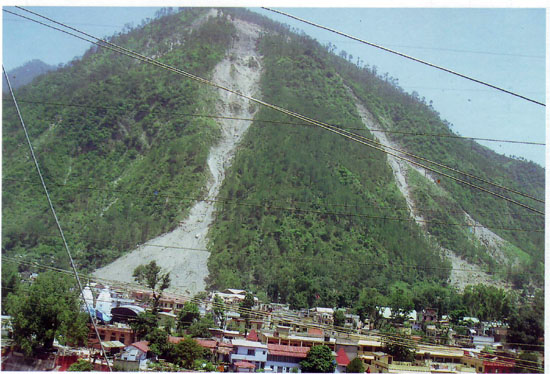
A landslide prone mass remains in a state of balance, as long as it remains undisturbed. Often the so called 'developmental' projects trigger landslides. Since Uttarksahi township is located on the bank of Bhagirathi River and the valley is not wide enough to support further construction or widening of the road, cutting of the toe of the hill was resorted to make room for the multistoried hotels and tourist lodges and also to widen the road. While the lose mountain mass is static and the soil held in place by the roots of the trees, the place remains tranquil. Cutting the toe of the hill was a reason enough to activate the slide.
The geomorphology of Uttarkashi district has all the features that induce landslides. The altitude of the area ranges from 2500 to 7138 meters. The higher reaches are snow clad. Glacial ice and seasonal snow have carved the sharp ridges and pointed peaks. These agencies produce plenty of rock flour and loosen the joints of rocks. The lower reaches have steep valley sides as Bhagirathi River has cut its valley on an earlier glacial valley. Thus the scenario is precarious, the gentler slopes on higher reaches have the glacial flour and loosened rocks, and the steeper slopes (>600) of lower reaches though have a forest cover yet change in land-use pattern is alarming.
There are two phases in Uttarkashi area during which total water content of the hill slope gets very high. One is during March-April, when the snowmelt is considerable to soak the lose slopes and other during monsoons. Thus water acts as a lubricant, loose material at top starts to slide down the hill, deforestation abates the misery and the entire mass of rocks, boulder, rock flour and trees and their stumps come rolling on the booming population at the base.
The loss of property though a consequence of the slide is a glaring example of self inflicted misery. The residents of the Mountain districts seem to forget and ignore the destruction by the past landslides and construct houses on the path of the old slides in blatant violation of regulations for construction. This has what has happened in Uttarkashi. It is for the residents to impose a self-discipline and religiously follow the regulations of the land-use.
Shatanu Sarkar and his colleagues from the Central Building Research Institute (CBRI), Roorkee, studied the slide in detail. In a paper published in the Current Science, they state that the crown of the slide is 700m above the road. In a satellite imagery the slide zone looks like a trident, with the recent slide forming the middle fork.
Fortunately, this slide was anticipated as the debris had already started falling. People and live stock were evacuated timely. Thus loss of life was not there. Once the mass wasting process picked up momentum there was no let up.
Varunavrat Parvat had already been affected in the past by landslides at Tambakhani and Gyansu. These two had originated from the same crown. The present one chose a middle path and dumped about 40, 000 to 50, 000 cubic metres of material on the buildings at the base. As per the reports from district administration nearly 362 dwellings including tourist hotels and lodges and part the buildings in the collectorate compound were destroyed. Rishikesh-Gangotri road was blocked for a length of about one kilometer at Uttarkashi. Clearing the blockage was quite a job as the slide material kept on continuously pouring. The slide material uprooted hundreds of trees in its wake. This compounds the problem for the future.
Natural or anthropogenic activity on these slopes can trigger them to slide down the hill. It is well known that earthquakes of MSK VII and greater trigger landslides. The area is severely earthquake prone. It is still a matter of investigation whether the present slide was instigated by an earthquake or was it triggered by the incessant rains on preceding days.
Anthropogenic activities are one of the major causes of landslide. It has been found that approximately 30,000 to 40,000 cubic meters of soil and rock needs to be excavated for construction of a kilometer of road in Himalayan terrain. While Mussoorie'Chamba road was being constructed it was found that construction triggered 148 landslides where the forest cover was less than 40%. Parts where the forest cover was 60% the number of slides was reduced to 118. Indiscriminate construction at the toe of the mountain must have excavated unimaginable volume of soil and rocks. A landslide under such circumstances is not an unexpected one.
Reports of geoscientists from various organizations that have investigated the landslide have one common recommendation. The habitation between Tambakahni and the present landslides are highly vulnerable. It is time that they are shifted to safer areas. Engineering solutions to contain the sliding mountain may not be possible.
The present slide was triggered after a gap of 12 years. The reasons thereof are quite perplexing. However, the reasons are more of academic interest. What matters is the safety of the population. People should not take Varunavrat for granted. Settling close to the base of the mountain may invite wrath of the Varunavrat Parvat again.
The state of Uttaranchal is on a fast track of development. It would be worth knowing about some more landslides of the state in the next issue that would haunt the development process for the times to come.
12-Nov-2006
More by : V. K. Joshi (Bijji)