
Apr 18, 2024
Apr 18, 2024
Kashmir, the heaven on the earth has been centre stage of natural disasters since times immemorial. Earthquakes, snow avalanches, landslides and floods all take their toll. Amongst these the local population is used to avalanches, landslides and floods, since they are almost regular annual features. It is the trembling earth that scares the people. Yet it is amazing that Kashmir the valley of lakes is there today because of the trembling of earth through the ages. The beauty of the place is such that Firdaus the poet in the court of Mughal ruler Jehangir called it a paradise on the earth. However, the gift of nature becomes a curse when human and animal lives are lost. Breadwinners are lost and also the jobs are lost. For the nature Kashmir is one huge area with picturesque, snow clad mountains, broad valley with lakes like pearls on a ring. The green meadows, the 'mergs' and the karewa fields of Pampore famous for saffron cultivation are a great tourist attraction. Alas people are unaware that apart from political turmoil Kashmir is also affected by turmoil within the womb of the earth. That is the stress generated by the moving Indian plate. Accumulation and release of these stresses leads to an earthquake. That is what happened on early morning at 3.50AM of 8th October, 2005. The earth shook and the deadliest amongst the Himalayan earthquakes in the human history had occurred. The epicenter of the earthquake lay in Kishenganga (Neelam) River valley some 150 km northwest of Srinagar and north of Muzaffarabad in Pakistan occupied Kashmir (POK). Because of the vicinity to the epicenter casualties were massive, 60,000 on POK side, whereas 13,000 people died on the Indian side. The quake rendered millions of people homeless. The database of seismicity of this region for the past 120 years available with the GSI reveals many earthquakes of magnitude ≥ 4 have shaken the area earlier too. Of these the earthquake of 30th May 1885, with its epicenter located 19.5 km west of Srinagar, was the most powerful. This earthquake took a toll of 3000 lives. https://www.boloji.com/articlephotos/Heaven on Earth Ravaged.jpg Landslides were in plenty, blocking the communication network. Water discharge of some rivulets increased and one of the nalas started to discharge black water. At that stage the GSI team suspected the phenomenon due to a surface rupture. This has been confirmed later by S.K. Singh of Instituto de Geofisca, Mexico and his co-researchers from The Institute, India Meteorology Department, Department of Science and Technology and National Geophysical Research Institute, Hyderabad. Using satellite imaging techniques they have been able to detect a near sub-surface slip of about five meters. V.C. Thakur of Wadia Institute of Himalayan Geology, India has also reported similar near surface ruptures. He says that in the segment of the Himalaya, south of the Great Himalaya and between the Satluj and Indus rivers, three large earthquakes of magnitude ≥ 7.5 have occurred during the last 450 years. These are from east to west, the Kangra-1905, the Kashmir-1555 and the Muzaffarabad-2005. In all these quakes ground was ruptured he claims and has recommend a watch on the un-ruptured portions of the frontal Himalaya, like Chamba-Doda sector and Simla-Garhwal sector. He has strongly advocated mapping of active faults in these areas. A Japanese team had already identified an active fault in Muzaffarabad sector earlier. Probably a few thousand human lives would not have perished had the governments on the either side been proactive to such reports. Detailed study by Joshi during the course of his PhD have shown that the earthquake was due to an activation of a subterranean fault which runs in almost NW-SE direction along the course of the River Ravi between Jangi and Rajpur. The fault passes underneath the terraces on which the historical town of Chamba is located. The River flows in northwesterly direction in this part. This geomorphic expression is against the normal direction of flow of Himalayan Rivers. They flow southwards. In addition, Saho 'Nala' at Chamba before joining the River Ravi suddenly takes a southerly turn and then joins the north flowing river. Yet another peculiarity is the wide valley of Ravi in this 20 km stretch. Using satellite imageries and ground checks Joshi says there is a differential uplift of the terraces of the Dhauladhar Range with respect to Pir Panjal Range. This is also confirmed by a higher gradient of the streams flowing into Ravi from Dhauladhar Range. Joshi concludes that there is a neo-tectonic fault running underneath Chamba. This fault is the root cause of earthquake events around Chamba. The epicenters identified in this area indicate that all the movements along the fault have taken place on the northeastern flank of the fault. This tectonic feature of Chamba has also been confirmed by the GSI. Faults that cause earthquakes or get activated by earthquakes are termed as active faults. Such faults need a constant watch as they can lead to a large devastating earthquake in future. In Taiwan the notorious Chichi earthquake of 20 September, 1999 (Mw = 7.6) was due to an active fault. This earthquake took a toll of 2100 human lives and left more than 8000 people injured. Like the fault at Chamba this fault too was ignored earlier and taken as a routine. With the rapid development in the science of seismology, now it is becoming feasible to identify the active faults. V.C. Thakur's conjecture that Chamba-Doda sector needs to be monitored closely for any possible mishap does hold water. Need of the hour is to install micro-seismic recorders and make use of SAR imageries to study the crust movement if any and forewarn the government and the society. One of the problems with the earthquakes is that sometimes their period of recurrence is as wide as 500 years. Human memory compared to this is short lived. We might forget, but the nature doesn't. Therefore it is better to abide by the dictum of the nature and take precautions in terrains like the Himalayas. The disaster in Kashmir attracted international reactions and sympathy. Integrated Regional Information Networks (irin) produced a documentary Aftershock, portrays the psychological consequences of such a disaster to which emergency can not respond, says the magazine Down To Earth (DTE). Quoting irin, DTE reports that the reconstruction of Kashmir's destroyed infrastructure will cost $6 billion. The area is now vulnerable to greatest landslide threat in the world. It means many more lives may be lost and much more agricultural land would be destroyed. The overall cost thus could be beyond comprehension. Earthquakes are a part and parcel of the Himalayan eco-system. Instead of waiting for them to occur and then provide relief to people the government can initiate measures like motivating people to go for earthquake safe houses, retrofitting of ancient and historical buildings, temples and mosques and construction of relief shelters on the far flung habitats. It is time to make use of the state of the art technological help available internationally and save those considered condemned by the Nature from premature death.
Srinagar in Kashmir of late has become used to rattle of AK-47 rifles and bomb blasts, but the tremors accompanied by a whizzing sound created lot of panic all around. People reported to the GSI team that it was difficult to remain standing. One had to sit down and somehow maintain balance. In Srinagar those driving an automobile even felt the shocks and abandoned their vehicles. Compared to shaking and fear, the damage was less at Srinagar.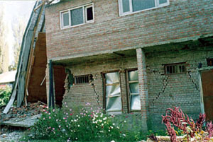 The residents of Baramulla, located on the banks of Jhelum River were jolted from their slumber by the tremors accompanied by a whizzing sound, as if a storm was approaching. Poorly constructed buildings and walls could not withstand the jolts and collapsed. A two storied structure that housed a furnishing show room collapsed, perhaps due to a poor foundation!
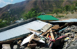 The macroseismic survey showed that the intensity of earthquake increased as one approached closer to Muzaffarabad. Naturally the damage was highest in those areas. Small hamlets with mud mortar stone walls and tin roofing were the worst victims. Some of the villages were completely razed to ground and the survey reported 'dwellings appeared like canopies of glimmering tin sheets placed over ground.'
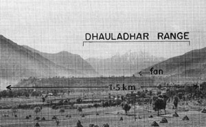 Incidentally an active fault in Chamba has been reported by D.D. Joshi a young seismologist of GSI. Chamba falls in the western extremity of Kangra re-entrant, a major structural feature of western Himalayas. Kangra re-entrant has shown a shortening of the earth's crust by 23 km since past 1.9 to 1.5 million years. In other words the shortening has been taking at a rate of 14 ' 2 mm/year. It means the region is under constant stress and faces a threat of major future earthquakes.
24-Sep-2006
More by : V. K. Joshi (Bijji)