
Apr 19, 2024
Apr 19, 2024
The French connection Pondicherry has is known to one and all but not its Dutch connections. On September 7,1693 Pondicherry fell into the hands of the Dutch and remained five and half years in their possession until March 1699. It is common knowledge that Pondicherry near the beach area after grand canal in the east is known as white town and the west of grand canal is called as black town. French are not responsible for this divide on racial lines. The Dutch wanted to carve out a white area exclusively for themselves. They wanted to relocate Indian people from the white town area. " It is also beyond doubt that in their project to relocate the Indian community in a separate area to the west of the establishment and keeping the old town on the seashore for themselves, the Dutch are also at the origin of the separation between Ville Noire i.e. white town and Ville Blanche i.e. black town " opines Professor Jean Deloche of the Institut Francaise de Pondicherry.
 During that period Dutch tried to develop the Pondicherry into a great manufacturing center. By entering into an agreement with Raja Ram, the ruler of Senji, they enlarged the territory under their control. Then they planned a new town based on the grid pattern. Jacob Verbergmoes, the land surveyor worked out a great urban project for the Dutch.. "The Dutch did not alter the layout of the old town i.e. the fort area to the east of the marshy depression. They kept the rough fence bordering the northern and southern part. They did not modify the fort and its outer works; on the contrary they even repaired the breaches made in the walls and the damage done to the bastions. They did not demolish the Malabar church for the native Christians or the French storehouses and the godowns but they decided not to rebuild the blocks of stone houses to the East of the Fort which had been destroyed by Francois Martin during the siege. The streets therefore had the same alignments. On the Western side on the other hand they completely changed the structure of the town. First they seized the properties of the French company and the religious orders, particularly the gardens"
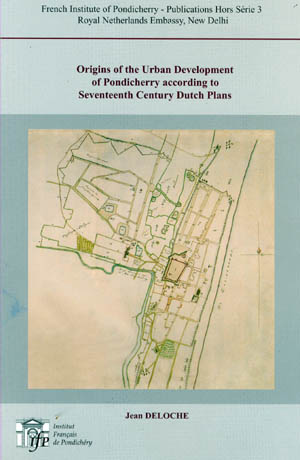
In fact, the Dutch plans of Pondicherry preserved at the National Archives at The Hague show that the orthogonal street pattern of the town is a creation of the Dutch. The plans of 1693 show that, in Francois Martin's time, the streets or lanes were following an irregular pattern, without any shape or symmetry, whereas in the plans drafted in 1694, during the Dutch occupation, one finds the design of a large new town, with a very regular geometric lay out, rectangular blocks of houses, separated by straight streets, intersecting at right angles. This great urban project of the Dutch company was adopted by the French who systematically carried out the extensive straightening out of streets into a planned grid, during the first half of the 18 th century" This is how Jean Deloche summarizes the contents of his book published in 2004 with 11 figures and 6 plates. " Origins of the Urban Development of Pondicherry according to 17 th Century Dutch Plans" is a masterpiece placing truth in its right place. People must appreciate the French Institution here and the French author who did not falter in placing truth above all.
The Dutch evidences had thrown more light on the History of Pondicherry's Urban Development. The Plan of the fortress and town "Poedechery" as it is currently being built on 20 th November 1694, available with Dutch Museum not only gives authentic version of the scene of those days but also spells Pudhucherri, the correct Tamil name instead of the corrupted version of Pondicherry.
In his book "City Planning and Architecture in Pondicherry " P. Richard thinks that the French adapted "their plan to the natural conditions of the littoral. This was possible because of the straight coast line was a very strong feature of the site and has from the beginning, determined the general orientation of the buildings and the direction of the streets, behind the dune, the low marshy lands and their outlet, running parallel to the seashore, increased this trend."
Ron van Oers is of the opinion that Dutch colonial settlements were built on a "Strict geometrical design to subdivide the usable area into building plots. All had a common image of being neat and well organized." On the orthogonal street model applied in Pondicherry he says "Dutch preferred this pattern since it was symbolic of an ordered, well managed society, hierarchical but democratic, it was emblematic for the hard working god fearing Dutch Calvinists".
"French appropriated this great design and that the extensive straightening out of the streets into a planned grid, systematically carried out by their governors in the first half of the 18th century, was therefore the extension of the existing Dutch orthogonal pattern into the rest of the town." Says Historian Jean Deloche who lives in Pondicherry. A great scholar who loves Tamil lives here unknown to fellow Tamils and he humbly refuses to get photographed because he wants his works to speak for ages to come.
11-May-2008
More by : N. Nandhivarman
|
|
I am a travel agent by profession and is trying to make a tour of "the Dutch Connection - India" Kindly inform me your contact no. - mine is 9422010467. Thanks |
|
|
I am at least 7 years late in commenting on this blog post. I am glad I stumbled on this to learn that for a very brief period Dutch controlled Pondichery and called it correctly by the local name Pudhucherri. Thanks to Nandhivarman. A correction in the article may be in order. It is stated that "The Dutch wanted to carve out a white area exclusively for themselves."and "the Dutch are also at the origin of the separation between Ville Noire i.e. white town and Ville Blanche i.e. black town " opines Professor Jean Deloche of the Institut Francaise de Pondicherry." I think Prof. Jean Deloche is misquoted here, for Ville Noire means black town and not white town as mentioned above. Also Blanche (Blank) stands for no color or white. All wine drinkers know this! Thus Ville Blanche would be the white town. The blog count says 2054 people read this article but nobody seemed to have noticed this error. May be it is time to keep the record straight. Cheers! |