Jul 21, 2026
Jul 21, 2026
The Start of an Utopia
In 1947, at the command of the British viceroy and with the consent of the future leaders of India and Pakistan, Sir Radcliffe drew a line in the sand, dividing the British empire in the Indian subcontinent into two new entities: the nations of India and Pakistan. The rationale behind this division was the pre-independence politics of India – a militant Muslim League led by Jinnah fuelled by the fear of being a minority in a Hindu-dominated nation, and an equally uncompromising Congress led by Nehru and Patel, which wanted independence from British rule as fast as possible, even at the cost of a divided nation.
Radcliffe’s job was next to impossible in the best of circumstances – the state of Punjab, through which the line was to be drawn – was an incredibly homogenous mix of three communities – Hindu, Muslim and Sikh – living together in close proximity and sharing the same physical space in villages, towns and cities, and bound together by social and economic ties fostered by generations of cohabitation. It was inevitable, thus, that entire villages and communities found themselves on the wrong side of the line, Muslims finding themselves in the heart of Hindustan and Hindus and Sikhs being stranded in Pakistan.
The word ‘stranded’ is used with some thought. The new states of India and Pakistan quickly assumed mutually antagonistic postures, and to be the wrong religion in the wrong country was at the time a life-threatening danger, in spite of official protestations to the contrary.
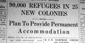 The aftermath of the partition of India led to the greatest known exchange of population in history. It is estimated that 15 million people crossed the Radcliffe line both ways, leaving behind in a now foreign land the major part of their immovable property, as well as most of their wealth. The infrastructure of both the new countries, already taxed to the limit, was simply incapable of coping. (Image shown from the Tribune Ambala, 1950).
Huge refugee camps were set up on both sides of the new international border. There was shortage of medicine, food, relief supplies, clothing, bedding, housing. To this was added the daily toll in human lives from the riots that took place on both sides of the border – disgruntled and angry citizens venting their ire on members of the other community, till recently their co-citizens, neighbors and even friends.
For north India, most of the 1950s were occupied by a mammoth effort to undo the damage of partition. To resettle people, to attract capital, to rebuild an economy torn by the ravages of independence. To build up infrastructure, and to provide housing and employment to its citizens.
The state of Punjab was the most grievously affected. Not only did it have the maximum number of refugees from across the border, it had suffered greatly both economically and socially. Its administrative and historic capital, Lahore, the pride of the Punjabi population, was now across the border in Pakistan. Reconstruction efforts in this state thus assumed a symbolic value – not only was this effort a Punjabi initiative, but it was also deemed to be a microcosm of India’s post-independence effort, and its success or failure would be India’s measure of its post-independence capability.
For Punjab, and thus India, the building of a new capital city was to quickly assume the importance of a project of national priority. This city was to be a showcase of the new India, a confident new nation, though based on its ancient traditions. It was also as much a social as a political experiment, designed to have space for all, from the poorest sections of people to the richest. In this sense, the new capital was also an expression of the Republic of India, based on the principles of liberty and equality. The socialist leanings of Nehru translated into his personal backing for this project.
Having taken the decision to treat Chandigarh as a material expression of the optimism and the dynamism of a newly independent nation began the struggle for locating the city within the complex matrix of Indian architecture, the history of which, in pre-independence India, stretches from the 5000 year old Indus Valley Civilization* to the British Imperial Capital of New Delhi. Located in between these two extremities are examples such as the cities of Jaipur** or – nearer home to Chandigarh -- Patiala***, which like all medieval cities in India, were structured around a centrally positioned royal palace, fitted with gardens for the king and his privileged few. But, for the majority of the Indian populace, living conditions in the average Indian city of 1947 – whether of colonial or indigenous origin – were no better than confinement to extremely cramped and obsolete structures. Since none of the existing could have served the purpose of an appropriate symbol or an architectural and social model for a newly independent, democratic nation, it became important to have a conscious departure and create “…a new town, unfettered by the traditions of the past…”****
Utopian Dreams
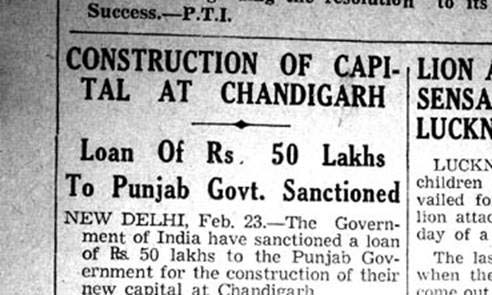
From the Tribune, Ambala. February 24, 1950
The brief presented to the architects was essentially a reflection of such individual and collective perceptions of what a utopian, modern capital of independent India should be. Chandigarh would be an aesthetic and social utopia and was described variously as “…the last word in beauty, in simplicity and in standard of such comfort as it is our duty to provide to every human being”1, “the world’s most charming capital”2 and “… a capital which would be a cultural, commercial and industrial center … from it would flow life and activity throughout the Province.”3 Above all, Chandigarh would be the first Indian city where opportunities for healthy living – interpreted as access to ‘water, drainage and electricity’ and ‘sun, space and verdure’ -- would be available to even the “poorest of the poor”4. The vision was of a capital that would serve as a model in city planning for the nation if not the world.
The near vacuum of indigenous expertise needed to realize this dream prompted the search for Western skill.5 Yet, conscious of the specificities of their situation, the search was narrowed to “…a good modern architect who was not severely bound by an established style and who would be capable of developing a new conception originating from the exigencies of the project itself and suited to the Indian climate, available materials and the functions of the new capital.” 6
Designing The City: Early Beginnings
The Chandigarh Project was, at first, assigned to the American planner Albert Mayer,7 with his associate Matthew Nowicki working out architectural details. Le Corbusier’s association with the city – as also that of his three associates, Pierre Jeanneret, E. Maxwell Fry and Jane Drew -- was purely fortuitous, a result of Nowicki’s sudden death in August 1951. The agreement with the second team had included acceptance of the Mayer Plan. Beginning with the practical necessity of re-locating the Capitol,8 this first scheme, with its concept of a fan-shaped city with a curved network of road and varying shapes of superblocks, was soon set aside. The rest, of course, is history.
The Urban Form : Generic Concepts
The present urban form of Chandigarh derives from the well-ordered matrix of the generic ‘neighborhood unit’ and the hierarchical circulation pattern resulting from Le Corbusier’s theory of the 7Vs, with a regular grid of the fast traffic V3 roads defining each ‘Sector’. The sector itself was a self-sufficient introverted unit, making contact with the surrounding fast traffic roads at four specified points. (9R) Connections with adjoining neighborhoods were made through its V4 – the shopping street, as well as the bands of open space that cut across in the contrary direction. Day-to-day facilities for shopping, healthcare, recreation and the like were arrayed along the V4 – all on the shady side. (10R) The vertical green belts, with the pedestrian V7, contained sites for schools and sports activities.
Disposition of Functions
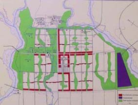 A city such as described above could be placed almost anywhere. But what distinguishes Chandigarh are the attributes of its site. The natural edges formed by the hills and the two rivers, the gently sloping plain with groves of mango trees, (10L) a stream bed meandering across its length and the existing road and rail lines – all were to play their role in influencing the distribution of functions, establishing the hierarchy of the roads and giving the city its ultimate civic form. 9 (Image shows the Master Plan of Chandigarh)
Connecting the various accents of the city – such as the Capitol, the City Centre, the University, The Industrial Area, etc. and scaling its matrix were the city’s V2s, of which the Jan Marg (People’s Avenue), was designed as the ceremonial approach to the Capitol with the Leisure Valley10 reinforcing its directionality. The second V2, Madhya Marg (Middle Avenue), cutting across the city, connects the railway station and the Industrial Area to the University. The third V2, Dakshin Marg (South Avenue) demarcates the Phase One of Chandigarh,11 which was designed for a population of 150,000, the ultimate one being 500,000.
Aesthetic Controls
Among the tools devised to regulate the city’s built mass were extensive visual controls covering volumes, materials, textures, fenestration, and even boundary walls and gates. Recognizing the crucial role of trees as elements of urban design, a comprehensive plantation scheme was devised. A protected green belt, the ‘Periphery’ set limits to the built-mass of the city.12
Architectural Components
The Capitol: Besides deciding the city’s layout, Le Corbusier, as the “Spiritual Director” of the entire enterprise had assumed the responsibility of establishing the architectural controls of the City Centre and designing the Capitol group of buildings -- the crowning glory and la raison d’être of the entire enterprise. The Capitol was to contain the three major functions of democracy – the Legislative Assembly, the High Court and the Secretariat. Besides the fourth major building, the Governor’s Palace (later changed to Museum of Knowledge) the complex also had a number of other “Monuments” such as the Tower of Shadows, the Martyrs’ Memorial and the Open Hand. In time he would also be assigned the responsibility for designing the Government Museum and Art Gallery, the College of Art as well as some other smaller works such as the Boat Club and parts of the Sukhna Lake.
 To the other three architects was assigned the role of designing ‘places for people’, containers for ordinary, everyday functions such as government housing, schools, hostels, buildings for work and entertainment and of grappling with the complex exigencies of the situation. Occupying vast tracts of land all over the First Phase of Chandigarh, it is these lesser-known constructions that were to define the constructed volume and architectural vocabulary of the city and, in general, direct the course of Modernism in India.
 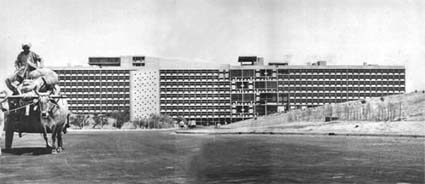 The fact that these are also the physical and visual manifestation of the social agenda of the new republic only reinforces the need to delve deeper into the basis of their design.
21-Nov-2004
More by : Ashish Nangia
|
|
being a citizen of chandigarh this is a good information of chandigarh and belong to municipal corporation chandigarh and also geat honour too. thanks for this . if you have more reports about the villages near by chandigarh kindly do the kindness..... |
|
|
Grate Work, need some old photos of chandigarh before its construction. |
|
|
very nice sir |
