Jul 25, 2026
Jul 25, 2026
Barmer, in Rajasthan, India is in the thick of the famous desert of Thar. One has to drive through the roads of the district to realize how the sand blown by strong winds, literally scrapes the body like a sand paper! At times the sand storms accompanied by rain storm turn the skies pitch dark and visibility becomes almost zero even during the day time. Living conditions are quite difficult. Apart from shortage, the quality of water is saline. Usually it is a low rainfall area, with average annual rainfall of 280mm.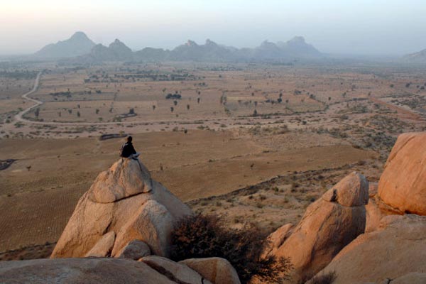
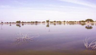 In case of a heavy and sudden downpour, in terrains like Thar, water logging becomes a major issue. Mamta Rawat of JNV University, Jodhpur, lead author of a paper on the consequences of sudden and above average rains reports 600 mm rain within 72 hours from 19-21 August, 2006. Such was the fury of the rains that several hamlets and small villages were wiped out. Villages like Kawas, Malva and Bhadaka, with a total population of about 10,000 were the worst victims. Extensive damage to houses and property was reported and about 47,000 cattle perished. The worst was not over. These villages remained submerged under water for more than 4-5 months. Some parts of Kawas village were under 3-4 feet water even seven months after the downpour.
Barmer area is famous for gypsum deposits. Gypsum is formed as a result of evaporation of gypsum rich sea water, like the precipitation of salt. From the salt pans of Gujarat one can easily discern that such areas are large flats with almost no outlet for water. However, in this case the area was a pan once upon a time! Normally in an area when it rains, the rain water is run-off-that is flows down the slope to a river, rivulet or a drain or percolates down to the ground water reservoir. Sometimes due to geomorphology or ground slope none of these are possible. Under such situations, large, shallow pools of water are formed and it stagnates.
Presence of gypsum, bentonite clay and fuller's earth (clay) and gypsite up to a depth of 30 to 45 cm compounded the problem. All these are impervious and also absorb water to quite an extent. Flat topography adds to the misery in such situations. Draining this stagnant water was a major problem says Mamta in her paper in the February 2008 issue of Current Science.
Our ancestors understood the significance of drains long back. Most of the remains of the past civilizations have well developed drainage network around the habitats. Our villages as such hardly have drains. Mostly 'kutcha' drains excavated by unskilled villagers act as storm water drains. In the villages like Kawas even such drains were not possible because of the layer of shale/gypsum/bentonite on the surface. The fury of rain was such that minor drains if any could not have faced the onslaught. As a result the ground remained slushy for months after the stagnant water was either drained/pumped out.
Stagnant water with carcasses of dead live stock became ideal breeding grounds for a variety of bacteria and vector borne diseases. Amongst bacteria E. coli were found in plenty. These are indicative of poor hygiene. Once such bacteria reach the digestive system, stomach ailments spread like fire. Many other bacteria which spread skin ailments, typhoid etc also thrived. Stagnant water acted as ideal culture for them.
The area affected by sudden downpour is shaped like a shallow bowl, with practically no outlet and an impervious ground aid to water-logging. Only way to drain water is to pump it out.
This was a special case. Such areas are plenty where sudden and heavy downpours not only paralyze life they even take away lives. The heavy rainfall event of 26-27 July 2005 took away 1500 lives with colossal property losses.
We are on the threshold of global warming. Such events can not be ruled out; rather their frequencies and fury might increase! The science of climatology is developing fast. Aided by fast computers and satellites the meteorologists have developed programmes which can accurately work out the frequency and distribution of such 'freak' rainfall events for better disaster management.
P. Goswami and K.V. Ramesh of CSIR Centre for Mathematical Modeling and Computer Simulation, Bangalore have enumerated a methodology based upon a programme developed by the Climate Prediction Centre (CPC) of the National Oceanographic and Atmospheric Administration (NOAA), USA. They have reported a high resolution analysis of heavy rainfall episodes, i.e. continuous rainfall for 24 hours, exceeding 250mm over the Indian region. The dataset developed by the NOAA, is based upon daily composite rainfalls for the period 2001-2006.
Goswami and Ramesh cross checked the dataset of the NOAA with the data of India Meteorology Department (IMD) and Tropical Rainfall Measuring Mission (TRMM). Once the reliability was assessed a number of hotspots of vulnerability could be identified. It was found that semiarid region of Northwestern India is a high vulnerability area for Extreme Rainfall Events (ERE). What happened at Thar in 2006 was a part of ERE only. The study also indicated that the Bay of Bengal is not vulnerable to ERE. But yes it is a different matter that due to vicinity with the delta the ground slope is feeble and a high population density with poor civic sense has choked the drainage system. As a result even without ERE a simple downpour of few hours floods the metro.
The information deduced from the datasets of NOAA is still in its infancy. At present it is also possible to identify areas prone to thunderstorms. However, the authors recommend more refined research and collection of data, so that the method developed by the NOAA can be used for rain/thunder forecasting at local level.
Extreme rainfall events are likely to increase in frequency and volume. They have different kinds of impacts on different terrains. For example, the Himalayan terrain faces the risk of landslides and mudslides; landslides in turn can temporarily dam a river and create a lake. When this dam bursts, the consequences can be gory for the downstream areas. In the Alluvial plains, the rivers are already choked to capacity due to rivers being used as refuge carriers. In the event of an ERE severe flood are inevitable. We have just read the consequences of an ERE in a desert terrain and this is not the first report. Such events have taken place in the past too. But this time it happened in the thick of the desert, where drainage is really a problem. The trap country of the plateau faces the threat of mudslides more than landslides in the event of ERE. Urban areas anywhere in the country face the worst ire of nature in case the rain gods decide to pour.
Disaster always strikes when one is least prepared. Refining information about ERE all over the country will help in better disaster management and pre-disaster mitigation.
Ancient Indian scientists/astrologers, based upon the position of constellations had developed their own methods of forecasting rain or thunder on regional scale. Some of them even used poetry to propagate their forecasts. Their predictions proved to be correct most of the times. May be the latest mathematical modeling methods work out to be more precise and save the urban masses from unexpected deluges and farmers from facing the brunt of drought or excess rain!
31-Aug-2008
More by : V. K. Joshi (Bijji)
