Jul 25, 2026
Jul 25, 2026
Connectivity is a key to development. Unless the places are well connected by roads a country cannot call itself well developed. In our countriy roads had come up pretty early. There are records of road connections between Taxila (now in Pakistan and Patliputra (Patna) during the Mauryan Empire. In the 16th century Pashtun emperor Sher Shah Suri had captured most of the north India and he built a fresh road along the right bank of Ganga between Agra, his capital and Sasaram, his home town and laid the foundation of the Grand Trunk Road (GT Road). This road had seen plenty of ups and downs in the history and politics both. Today it is south Asia's oldest and longest road (2500 km) linking Sonargaon in Bangladesh with Peshawar in Pakistan. Thus even the history clearly demonstrates the significance of roads. And no doubt there is an urgent need for a direct link between the east and the west Uttar Pradesh. That is why the present U.P. government has launched the 853 km long Ganga Expressway project at a cost of Rs 40 thousand crore linking Ballia in the east with NOIDA in the west U.P. As per an announcement of the U.P. government 36 tehsils of 19 districts will be benefited from this project. This project will be constructed on the embankments on the left bank of the river Ganga. It may be noted that the left bank of Ganga River is more devastated by floods. Hence millions of flood affected will get relief through this project and the farmers of these areas will get the opportunity to procure two crops, which in turn will improve their financial status. 10 major development areas, each of approximately four to five thousand acres will be developed in the Express-way Project. These areas will be equipped with infrastructure facilities like electricity, water, roads, health services, educational institutions and housing. In the development area, industries will be established in 10 thousand acres. Through five hundred large-scale industries six to seven thousand persons will gain employment while three lakh persons will be directly or indirectly employed in medium and small-scale industries. The local population gets maximum opportunities of employment in these industries, for this technical/commercial educational and training institutes will be established in the development areas in fifteen hundred acres. 20 ITI level, 10 Polytechnic level and 5 Engineering level institutes along with Medical College and various Paramedical schools will also be established providing employment to 20 thousand persons as well as benefiting 20 thousand students. 5 hundred agro-based large and small-scale industries will also be established which in turn will directly benefit the farmers. It is expected that seven to eight lakh persons will either reside or work in these areas in the next ten years. To serve them, commercial establishments, shops, hotels, bus stations, truck terminus, buses and taxies will also operate which in turn will provide employment to one to two lakh persons. Apart from the need for an expressway there has been a dire need for flood control measures in the region through which the super highway will pass. The government's statement categorically says that the left bank of the river gets more devastated by the floods annually. That is why the need for a bund all along the left bank of the river is stipulated. Question is why more floods along the left bank of the river, compared to the right bank? Rivers have a peculiar character of scouring the convex side in case the stream makes an arc and sediments brought by the river are deposited on the concave side. In the giant arc of the Ganga this is exactly what the river has been doing since thousands of years. The right bank or the convex side being higher is scoured as a result often cliffs are formed. The river deposits its load of sediments more on the left bank, making it more fertile. No doubt industrialization and urbanization of Khader will usher an era of prosperity in the region, but a concretized Khader may stop rainwater to percolate down to subsurface depths. A situation in which Ganga may even dry up says Prof Singh. The future appears to be too scary to imagine motor vehicles running on the dry bed of Ganga and nearby habitations getting buried under mounds of sand like Thalakkaddu in Karnataka! 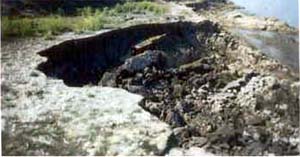
Well all this sounds like a dream come true for the densely populated Ganga-Yamuna Doab.
Development of a state is the responsibility of the government. However, it is also imperative that the government strives for a sustainable development and not just mere development. Whether the current project of Ganga Expressway is sustainable or not needs to be analyzed. To achieve that it is time to know some bare truths about the natural factors that have been operating on the land across which the project is envisaged.
The inter-fluve or the land between the major rivers Ganga and the Yamuna is known as Doab. The rivers Ganga, and Yamuna and their tributaries like Chambal, Tons, Kosi etc have been since ages painstakingly bringing the rock flour ground by them while hurtling down the mountains. This rock flour according to the grain size is either sand, clay or silt. The rivers toiled hard to deposit layers after layers of this material to form the present day's granary, the Doab. Today Uttar Pradesh is what it is because of the hard labor carried out by the rivers, which still continues.
Ganga makes a huge arc between the point it emerges out of the Siwalik ranges near Haridwar in the northwest and Patna on the east with a convexity towards southwest. The Yamuna runs more or less parallel to the Ganga till they meet at Prayag. These rivers apart from making the giant arc seldom flow in a straight course, rather their courses are sinuous all along.
To a layman, the two banks of the Ganga appear similar. However, Prof. I.B. Singh an authority on Ganga Plains and an internationally renowned earth scientist of Lucknow University says that boreholes drilled near Panki, on the right bank and Unnao on the left bank of Ganga show a peculiar sub-surface setup. At Panki the top 300 m of the sands and clays recovered from the borehole originated from the Himalayas, while underneath them is found the 'maurung' or coarse red sand which has originated from the older Aravali ranges on the south of Ganga. On the other hand, the top 1500 m pile of sands and clays recovered from the borehole at Unnao have come from the Himalayas and below that is the 'maurung' from the southern hills. Thus he says the left northern (left bank) side of the river 'sank' down by about 1200 m. In other words the Ganga flows through several such lineaments or weak planes formed by the past earth movements. The epicenter of the notorious Bihar earthquake of 15 January, 1934 was also in one of the lineaments followed by the Ganga says Prof Singh.
The river, therefore, apparently calm and flowing forward, eager to meet the sea at the Bay of Bengal has a turbulent history. Since the Indian Plate is constantly moving underneath the Asian Plate, stresses always keep building in the sub-surface. These lineaments unfortunately become release points for such stresses.
Ganga plains are divisible into 'Bhaber', 'Terai', 'Bangar' and 'Khader' areas. Each one of them has a characteristic says Prof Singh. Thus Terai and Khader are famous for lush green vegetation and agriculture. Be it rich sugarcane growing area of Budayun or the guava belt of Unnao, are all situated on the Khader of the Ganga.
Khader's greatest contribution is to make the Ganga flow perennially, says Prof Singh. He says 'Ganga will not dry up even if the Gangotri Glacier melts, but if Khader stops feeding ground water to Ganga, it can go dry'. In addition Khader is one of the richest sources of groundwater to the farms and habitats developed on the surface.
Khader is crossed by several rivulets which drain into Ganga in this region, says Prof Singh. They act as a buffer during the floods when excess water escapes and takes the brunt of the floods.
Ganga is not merely a huge drain that flows through the plains of U.P. It is a mighty river system says Dr Vibhuti Rai a Professor of Geology in the Lucknow University and he too repeats that the difference in the levels of the two banks is because of the constant 'rumblings' in the sub-surface or neotectonism activated by the imperceptible movement of the Indian Plate towards the Tibetan Plate.
A road that too on a bund all along the left bank of the Ganga would be a catastrophe, says Vibhuti. He says the Ganges is not just an artificially created stream, rather it is a river system joined by several streams. The bund therefore will have to have N number of bridges all along to let the tributaries debouch in to Ganga. In addition Ganga has a flood plain of five to seven kilometers on the left bank.
A river has a normal channel which it occupies during the lean period. Then there is a wider channel which it occupies during the monsoon. The spill over water or the floods spread beyond the wider channel. Usually the flooded part forms a sort of flood pathway of the river. Thumb rule says that the flood pathway should be left undisturbed. We know that we are mighty and we can tame any river. But what we are not trying to understand is the fact that taming a river along a length of few kilometers near a habitation is different than taming the entire 853 km length. The moment the bund comes up it will act as a barrier between the natural slope of the ground on the left bank and stop rain water from reaching the river. As it has happened in many towns, like Lucknow, the bunds of Gomati River cause water logging every year during rains, because they do not permit water to flow to the river. Likewise the Ganga Bund would act as a check dam.
Now imagine the scenario after a few years, the bund on the left bank and the raised right bank both would 'channelise' a river that had been swinging through the plains like braids of a maid. The river would naturally deposit its sediment load in its channel only, as it would not be able to splay out. The stream will gradually choke under the load of its own sediment. This would not only upset the hydrodynamics of the river but will also cause the river water to find escape routes via the tributary streams and many times the nearby habitations would be flooded.
Shashi of Uday Pratap College, Varanasi and A.K. Dwivedi of Gorakhpur University have carried out some studies about the aftermath of the Ganga Expressway Project and published their views in the Current Science. As per their projection 1,047,000 x 8 x 7 cubic meter fertile agriculture land of doab will be usurped in creating the bund along the left bank of the Ganga. They question, is it pertinent to sacrifice fertile land for the road when the food grain crisis is raging throughout the world? In order to make the bund of this magnitude lots of earthwork will be required. Naturally the contractor will excavate it from the nearest point. The excavated ground thus will have giant depressions which will be filled by rain water. Such ponds will be open invitation for mosquitoes and with eastern U.P. already reeling under vector borne diseases, these will add to the misery.
The industries they say can produce bread but can not grow grains. This region has been a granary of U.P. since times immemorial converting it in to an industrial belt may not be prudent!
Shashi and Dwivedi have also raised the problem of disposal of effluents generated by the new industries and townships along the bund. The waterlogged tracts along the river will lead to alkalization of soil thus the fertility of the remaining land will be deteriorated beyond redemption.
Well the problems are many, but the government has already taken a decision, therefore it is not likely to roll back. However, Shashi and Dwivedi have recommended a revival of river transport. This would be a cheap link at least between Bulandshahar and Ballia. It will not involve any earthwork. On the other hand it would help in keeping the Ganga clean. Dr Vibhuti Rai sites example of Yantze River of China. Instead of being a river of sorrow today it fetches millions of Yuan from the tourists as it offers one of the best river cruises.
Ganga has an active flood plain of 5-7 km. This flood pathway looks like an ocean of water during rains. In case construction of a bund with a road atop is the only recourse left to 'develop' the region, the flood pathway should be left untouched says Prof I.B. Singh, because the might of the river is beyond the power of engineering. It can be tamed for some time but not for all times to come.
Prof Singh suggests that if construction of a bund all along the Ganga with a road atop may be done on the Bangar region as it will have minimum impact on the environment.
13-Jun-2008
More by : V. K. Joshi (Bijji)
|
|
Thanku dude. |
|
|
hello dude you need to advertise it more its a good articale needs to be distributed |
|
|
Thank you Nidhi, I am glad you liked it. |
|
|
a very informative article mamu........ |
