Jul 27, 2026
Jul 27, 2026
Geography students know that the glaciers carve a 'U' shaped valley. Thus it is common perception that the glacier's limits end where the 'V' shaped valley carved by a river starts. Is it really like that or the limit of glaciation is controlled by some other natural agency too? This has been baffling the geologists since quite some time. If there was another agency, what it could be is yet another poser. Glaciers as such are a storehouse of past climatic information. With advanced techniques it is now possible to work out precisely the past climatic details by studying the remnants of glacial sediments and moraines. Such areas that contain the clues of the past are unfortunately remote and quite inaccessible. It requires lot of grit and determination to reach those places and search for the clues. A team of six determined earth scientists and physicists including N. Juyal, M.G. Yadava and A.K. Singhvi from Physical Research Laboratory (PRL), Ahmedabad; R.K. Pant and N.K. Saini from Wadia Institute of Himalayan Geology, Dehradun and N. Basavaiah of Indian Institute of Geomagnetism, Mumbai dared to threadbare the area around Garbyang, Pithoragarh district in Uttarakhand and the information they could gather has proved to be of immense value 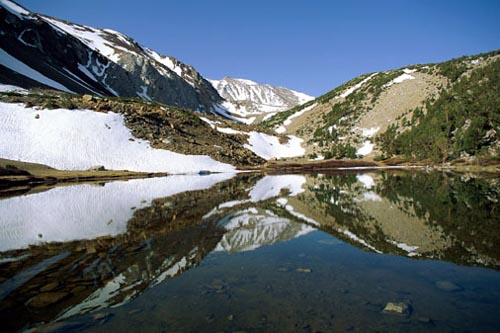
Juyal states in a joint paper published by the team in the prestigious journal PALAEO, that the higher Central Himalaya is a narrow strip of mountainous terrain between the Great Himalayan Range and the Indo-Tibetan water divide. This is a region that has preserved records of ancient glaciation. It is significant to note here that glacial melt water began to flow as rivers. The flow of these rivers got impounded, because the downstream side was somehow lifted up. Such uplifts are possible during massive earthquakes. Thus lakes were formed and such lakes lasted for considerable time and were eventually drained. Garbyang was one such lake. The drained waters of the lake exposed the sedimentary record of the lake. Such unaltered pages of the climatic and tectonic history of the Himalayas are highly sought for.
The Swiss launched a scientific expedition to the remote Himalayas in 1930s. Heim and Gansser two pioneering Swiss geologists found varve-like deposits at Garbyang. Glacial varve (Swedish varv) are the fine clays deposited in lakes by the glacial melt. These are deposited in fine layers, each representing a year of glacial melt. In other words varves or varvites (rocks) are useful tools to unfold the past glacial/climatic history.
Varves are exposed between Chhiyalekh to Gunji in the Kali River valley, record Juyal and his co-workers. Chhiyalekh pass at 3100 m is the divide that defines the southern limit of U-shaped Garbyang basin. Varves or the glacial lake sediments of Garbyang are estimated to be around 100 m thick. However, the steep cliffs make most of the succession inaccessible. Top 28 m part is accessible which was been studied by Juyal et al. The type of varves at Garbayang are typical of deposition in a lake that was already formed while the glacier existed, a fact confirmed by the terminal moraine that proved to be much older than the lake sediments.
Juyal and his team feel that the stream flow from the glacier was blocked by the terminal moraine. This led to the formation of a lake, which grew in size with the passage of time. Lake waters are always placid and calm. Geologists term such environments as low energy environments. In such conditions the finest of the sediments are deposited in layers. Snow melt increases with the advent of summers and thicker layers are formed, whereas during winters due to reduced snow melt the layer of sediments are thinner. One can count in such varves with ease, as to how many winters and summers the area has witnessed in the past.
The natural dam formed due to accumulation of moraines can not last for ever. The day it gives way, there is a sudden release of water from the impounded lake. This caused sudden influx of water from the source area. Naturally the energy regime of the lake had changed. In now the so called high energy environment larger grains started to get deposited. Thus Juyal reported gravel layers which marked the draining of the lake.
Trans Himadri Fault (THF) an ancient tectonic feature which was formed some 23 MA is a feature that dominates the southern margin of Garbayang lake. Geologists report that this fault though apparently dormant has been reactivated several times in the past at 19 MA, 11MA and again at the end of Pliocene, some 1.75 MA. Reactivation of a fault of such great magnitude implies massive earth movements.
A minute study of the 28 m of the layers of fine lake sediments and the thick moraines has yielded great clues.
Juyal and his co-workers conclude that during the past 1.75 million years glaciation in the Central Himalayas was controlled by the structure of the basin, which in turn depended on the tectonism. Thus THF limited the advance of the glaciers. As the glaciers advanced through the permissible space they generated plenty of glacial flour and moraines. The terminal moraines at the THF were responsible for damming of the melt water, leading to formation of the Garbayang Lake.
Earth's past climates deduced from the oxygen isotopes have revealed alternating warm and cold cycles. Called as Marine Isotope Stages (MIS) the climatic history has lots of fascinating things. For example in the past 2.35 million years about fifty such cycles have been reported. Though corroborative evidence for even half the numbers of such cycles have yet to be obtained, yet the work of Juyal and his colleagues is a step forward towards the past. According to them the sediments are equivalent to MIS stage 4.
Detailed study of varves revealed high frequency, low magnitude climatic oscillations between 18'3 and 13'2 thousand years (ka). Fine sediments of varves indicate prominent cooling between 12 and 11ka which is attributed to younger dryas. Younger Dryas represents the 'Big Freeze' between 12700 to 11500 years before present. It was a global phenomenon during which apparently everything remained frozen. Unlike today's global warming, had the media been developed a global cooling would have been the daily headlines!
Juyal and his colleagues observed seismicity with the help of preserved, deformed layers of the varves at Garbayang. A dating of these sediments indicated that THF was active between 20 and 17 ka and 14 and 13 ka. An active THF is something quite serious. Because in case the fault is reactivated to the scale on which it was operating in the days gone by, it can cause massive destruction. In addition to Juyal et al past seismicity in Grabayang area with the help of soft sediment deformation has also been confirmed by B.S. Kotlia and K.S. Rawat of the Kumaon University, Nainital. Kotilia and Rawat interpret liquefaction of sand layers due to past earthquake/s.
The Himalayas, especially the Central Himalayas have lots of clues still hidden under the sub-surface that need to be unearthed. These are the clues about the past tremors that shook the Himalayas or even made them rise. In the present context any information of such possibility is significant, because we are populating the calm mountains vigorously. An earthquake can lead to great loss of life in densely populated areas. Relief measures in Himalayas become a problem in such an eventuality because of disruption of communication links. It is better to take precautions.
The designs of earthquake resistant houses at present are as per a maximum anticipated shaking. The strength of the THF that has re-carved the entire valleys shows that a dense population can be an invitation to massacre if the fault decides to repeat its past.
28-Oct-2007
More by : V. K. Joshi (Bijji)
