Jul 25, 2026
Jul 25, 2026
Geomorphological and glaciological studies of the valley have assumed significance because of the huge annual congregation of people there. At a place like Badrinath where congregation is large and naturally vehicular movement is also excessive during pilgrimage season, media and society are certainly worried about the safety of the place and the people. In addition the area being in high hazard zone for earthquakes is always considered vulnerable. Luckily till date no major mishap has been reported but for a damage by the great Himalayan earthquake in 1803. A few months ago media had reported cracks and risk of huge boulders falling down from Neelkanth Mountain forming the back ground of the town. However, the studies conducted by Geological Survey Of India confirmed that such projecting boulders are a common feature in the Himalayas. P.C. Nawani, Director, GSI supervising the hazard studies in the area says there is no risk to the holy town because the Neelkanth Mountain is eight kilometres away. However, the risk from an earthquake can not be ruled out. The risk from rolling boulders is apparently less because of the wide valley.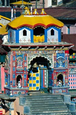 For a pilgrim, Badrinath the holy town on the bank of the River Alaknanda at an elevation of 3133 m above mean sea level is the ultimate desire. Badrinath was established as a pilgrimage site by the Adi Shankaracharya in the ninth century. More than six lakh people visit annually the temple for pilgrimage. The broad valley with the temple between the Nar and Narayan mountains makes a majestic picture.
The valley would have been like one of the usual Himalayan valleys, narrow with sharp edged mountains on both sides. Call it the will of the Lord Vishnu or the efforts of the world's best carver, the glacier, the present landscape was created.
How the temple came up at Badrinath is partly myth and partly history. However, the carving of a broad valley was due to erosion by the glaciers. Natural agencies like ice, water and wind are greatest carvers of a landscape. Amongst these glaciers are one the most powerful agents that have produced huge deposits of eroded rocks and rock flour.
Earth scientists from Department of geology, H.N.B. Garhwal University including H.C. Nainwal, M.Chaudhary, N. Rana, B.D.S. Negi and R.S. Negi and N. Juyal and A.K. Singhvi of Physical research laboratory (PRL), Ahmedabad, India joined hands to study and establish a chronology of glaciation of Badrinath valley. The findings are significant not merely from academic point of view but also from the view point of future development of the holy town. It is certain that in the times to come the number of pilgrims will continue to swell, thus the town needs special efforts to sustain the onslaught of the floating population.
Before we ponder upon the chronology of glaciation, we must understand what are glaciers and how are they formed! Glaciers are masses of ice which, under the influence of gravity, flow out from the snowfields where they originate. A snowfield grows whenever a balance of snow the snowfall is left over to accumulate from year to year. As the snowfield grows in volume the pressure on the ice that was formed earliest is sufficient to start the outward flow of the glacier. The transformation of the snowflakes to glacial ice is a complex process. End product is a granular aggregate of interlocking grains, with each grain being a crystal of ice. Each year during winters the volume of such crystal goes on increasing and a stage comes when the ice mass starts moving down the slope due to gravity.
As the glacier advances it carves a niche in the valley. The mass of ice is so much that glacier can be compared to a slow moving bulldozer, which pulverizes anything underneath to a fine rock flour and removes chunks of material from sides. Smooth rock surfaces that escape glacier's wrath develop striations as if clawed by a cat.
Glacier starts losing volume due to melting, evaporation and calving of ice bergs. This process is called ablation. Maximum ablation occurs in the summers. Growth of the glaciers in India depends largely upon the Indian Summer monsoon (ISM), being a major source of moisture. The valleys carved by the glaciers and the material left behind them are easy to identify. Thus if it is possible to date the material it is possible to find out how much was the glacial cover and in turn establish the patterns of the past climates.
In a valley glacier like the one that was present where the holy temple of Badrinath is situated the highest point of lateral moraines coincides with the Equilibrium Line Altitude and terminates with at the snout. Thus if it is possible to find out the highest point of the moraines it is possible to find out the exact configuration of the glacier including the position of the snout. Most studies have indicated multiple events of glaciations in the Himalayas during the last chapter of the earth's history that is Quaternary period. Usually quantitative estimation of pre-history events is done with the help of dates obtained from organic material. In case of inhospitably cold regions of Himalayas it is difficult to find organic remains of the past. Thus standard radiocarbon-dating techniques become redundant for such terrains. Instead Luminescence dating technique has found favors with the geologists and researchers of past climates.
H.C. Nainwal and his co-workers were able to establish a chronology of glaciation with the help of cited dating technique. The magnitude of variability of Quaternary glaciation in Alaknanda valley can be made out from the piles of moraines. The preserved moraines of the valley have been grouped in to Alaknanda Stage I, Alkapuri Stage II and Satopanth Stage III glacial moraines. They observed that the Stage I glaciation was most extensive and it reached south of Badrinath up to 3000 metres above mean sea level (m asl), whereas the Stage II and III were restricted around 3550 and 3700 m asl respectively.
Nainwal and his team were able to trace the moraines of stage I glaciation for a distance of around five km downstream of Badrinath shrine. Being oldest these moraines are less preserved. Lots of material has been washed by earlier debris avalanches and water action. However, the linear hummocky ridges covered by birch and junipers are the remains of what must have been a gigantic glacier. This is confirmed by near 100 m thickness (opposite bank of Rarang Chatti) of the stage I moraine material. The production of glacial flour depends largely on the increment of the ice mass and the amount of snow melt decides the quantity and grain size of the material transported. Thus in a regular annual pattern glacial flour is deposited usually in the pools (glacial lakes) formed downstream of the snout of the glacier. in layers of finer and coarser material called Varves. The 100 m thickness of the oldest moraine mostly has these varves as the evidence of the past glaciation. These indicate the depth of the lake that must have been present in the valley in the days of the yore.
Evidences of Stage II glaciation are better preserved. Glacial action produces a strange admixture of fine clay and huge boulders. Sometimes one wonders if this is the work of the nature or some demon! The fine clay is naturally a product of rock grinding at the floor of the glacier. This powdered mass of clay is deposited over pre-existing valley configuration. This often acquires shapes of giant whale shaped mounds called drumlins or 'basket of eggs'. Nainwal and his colleagues have recorded such drumlins near Vasudhara.
The Stage III or the youngest moraines (present glaciers) have been reported by them parallel to the glacier. This moraine starts from an altitude of 5000 m asl in Bhagirath Kharak glacier and 4700 m asl in Satopanth glacier and terminates few hundred metres below the present day snout where it forms a curvilinear ridge.
Armed with this information from the field and samples from well identified locations, these glaciologists resorted to Optically Stimulated Luminescence (OSL) dating technique to establish a chronological succession of glaciation in the valley.
Though, the study requires further refinement in the form of more data on dates. The results so far are quite amazing. A luminescence age of 12 Ka has been obtained for the moraine of Stage II located at 3600 m asl. There is a depression between the moraine and the terminus of Stage II glacier. This was because when the glacier started to recede there was a temporary earth movement or some kind of upheaval. This is further corroborated by the drumlins.
After the last glacial maxima (LGM) that is about 18000 years ago the Indian Summer Monsoon (ISM) had started to weaken. Lesser monsoon reduced the extent of the glaciers in these valleys. Taking a cue from these evidences, Nainwal and his co-workers have postulated that the Stage I glaciation in the area predates the LGM. In other words it is older than 18000 years before present.
The Stage III glaciation has given dates of being about 4.5 Ka old. There is a marked glacial activity evidenced with these dates. The researchers conclude that between 12 Ka till the onset of Stage III that is about 4.5 Ka there was a marked reduction in the ISM leading to reduced glacial activity. The heap of moraine found near the present snout is believed to have been a product of glaciation some 400 years ago due to the 'Little Ice Age'.
Well this clearly shows that the climatic fluctuations on centennial scale matter more than annual fluctuations. Global warming is inevitable the climatologists foresee. But the past evidences have always shown that after a warming there is always a cold phase.
What is alarming is the rapid 'development' of Badrinath valley. As evidenced the glacial material that is present to a depth of 100 m in the valley is not a very stable material. It is incorrect to permit many structures and also multistoried structures without conducting proper geotechnical and geo-seismic studies. There is a clear cut evidence of a prehistoric lake that existed in the vicinity of the Helipad at Badrinath. Such lake sediments can get compacted/disturbed due to vibrations and cause local damages. A detailed knowledge of the glacial history of Alaknanda valley will be certainly useful while making further development plans.
07-Oct-2007
More by : V. K. Joshi (Bijji)
