Jul 25, 2026
Jul 25, 2026
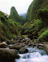 Remember your last trip to the Himalayas ! You must have watched the rivers hurtling down through the valleys carrying their load of assorted boulders, pebbles and cobbles. These are actually the source of alluvium. By the time these boulders reach the plains, water action grinds them to sand and even finer silt and clay. Rivers in spate bring more and more material to be deposited on the plains. Sudden change of velocity on reaching the plains forces the river to drop its load and the process has been going on since times immemorial.
Here it is pertinent to mention that as the Indian plate began to collide with the Asian plate around 20 million years ago; a deep trench called the Fore-deep was formed south of the rising mountains, the Himalayas. Consequently, the streams like Chambal, Ken, Betwa and their tributaries originating from Vindhya Mountains developed a sudden high gradient. Even today unlike other rivers of north India these flow northwards and have a higher gradient than the gently swaying mighty rivers the Ganga and Yamuna. River systems were realigned consequent to the rise of the Himalayas and ultimately rivers from the Himalayas and Vindhyas dumped their load of sediments in the fore-deep. It was gradually filled with alluvium and formed the plains, which became a center of attraction for our nomadic ancestors to develop an agrarian society.
The journey down the river makes the sediments roll with water which gives them a rounded shape. Ultimately it is this roundness which affects the subsurface reservoirs of water. It gives the pile of sediments the desired air spaces or porosity and a greater permeability or ability to allow a fluid to travel through their pore spaces. These characteristics make alluvium the best store- house for water. It is astonishing to note that latest laser based techniques have dated groundwater of Sahara as millions of years old.
In other words the alluvium is like a bank vault and water is stored up like money. As said in an earlier article we can not just go on drawing money from the bank without making deposits, same way the water stored in the alluvium needs to be recouped to save the water account from becoming bank-corrupt. Normally the aquifer is recharged through rains. The changed rainfall pattern or less rainfall, more withdrawal of groundwater and above all the concrete of the urban areas minus trees have adversely affected the groundwater recharge.
Groundwater in alluvial terrains can be recharged artificially on micro and mega scale. Some of the techniques are:
 Surface Techniques
Flooding
Under normal circumstances monsoon floods in alluvial plains spread enough water on the surface to percolate down to the depths of aquifers and recharge them. Same can be achieved artificially through a network of distribution network and a thin sheet of water is spread over wide area. However, this method is successful only if the topography is flat and the surface is pervious.
Basin and Percolation Tanks
One of the most common methods of artificial recharge, it involves impounding water in a series of tanks or basins preferably with effective depth of 1.25 m. A study carried out in Bauman basin, New York showed that greater or lesser depths than this reduces the rate of infiltration of water. This technique is suitable both for alluvial and hard rock terrains where a pile of weathered rock material generally forms the aquifer.
Stream Augmentation
Rivers have a peculiar character. At some places they draw water from the aquifer and at others they feed water to the aquifer. Hydrologists are able to ascertain these characters through some simple tests in the area. In case the condition is favorable that is river is found to feed the aquifer, the surplus water of the river is directed to the aquifer through check bunds. Same results can be obtained by widening the width of the stream bed, but it is not possible in areas where the banks are inhabited. The height of such dams is kept at two meters and as per requirement and suitability a number of such dams can be made in the stream. Only disadvantage of this method is that the stream has to be frequently de-silted.
Ditch and Furrow method
This method involves making long, flat bottomed ditches and furrows. The pattern of these can be varied according to land and surplus water available. The surplus water of the river or canal is diverted to these ditches and thus a larger area is available for water to infiltrate down to depths. The density of ditches depends upon the transmissibility of the surface. In areas with finer soils, ditches have to be closely spaced.
All above methods require a prior knowledge of the sub-surface geology, depths to water table and groundwater flow directions. Impervious lenses and layers in the subsurface impede percolation. Quality and quantity of water available for recharge has to be established before launching construction. Engineering costs can be cut down considerably by knowing the size of the catchment, intensity of rainfall and rate of recharge, which is governed by the geology of the area.
Proper design is pertinent
Basin and percolation tanks and ditch and furrow need to be designed properly to get the best results and also to avoid infructuous expenditure. For example, in Delhi for an area of 100 sq m as per the norms of the Central Ground Water Board (CGWB) the volume of the recharge tank should be 2.125 cu. m. Similarly the volume of the recharge trench for same area in Delhi should be 4.25 cu. m. Once the volume of the structure required has been established the length can be calculated easily.
continued
16-Jul-2006
More by : V. K. Joshi (Bijji)
