Jul 27, 2026
Jul 27, 2026
Mangroves are the interface between the sea and the land. They are like 'shock absorbers' in case of a severe tide, tsunami or a cyclone. In the sub-surface the roots of the typical vegetation of the mangroves perform a balancing act between the saline water of the sea and fresh groundwater. Sunderbans are considered to be world's single largest tract of mangrove forest characterized by an assemblage of plants that can grow only in the coastal zone between the land and the sea. Growth of the mangrove depends upon the frequency and duration of flooding, the nature of soil and the degree of admixture of saline and freshwater at the mouth of the river. The Ganga ' Brahmputra Rivers' delta is covered by Quaternary sediments. Quaternary period is the last chapter of the earth's history spanning about 1.81 million years, out of which past 10,000 years are termed as the Holocene. Dr. Chanda and his team punctured ten boreholes spanning a wide area of west Bengal delta at sites thought most susceptible for rising sea-level and land subsidence during the Holocene. Depending upon the capability of the flora to survive in the brackish waters of inter-tidal zone and at comparatively higher elevations where salinity is much less, the mangrove habitats are grouped in to two categories, viz. the core mangrove and the back mangrove. The back mangrove flora is intolerant of the salinity hence can not thrive in parts of the delta lashed by the tides. The drill core samples revealed the presence of ten bio-zones with layers of peat at varying depths typical of mangrove vegetation and flora. Out of these the lowest two were dated as pre-Holocene as- older than 10,000 years before present (ybp) and the remaining eight were of the Holocene. The information obtained from the bio-zones is of immense use for obtaining proxy records of the past climates. It appears that while the northern latitudes of Europe were freezing, the lower Ganga delta remained unaffected by the late Pleistocene glaciations. Instead the wealth of information points towards a tropical wet-humid climate for the region. The presence of 'kankar' in the samples points to in-between periodic long and dry summers too. Transgression and regression of the sea is a normal natural phenomenon. Radio Carbon dating of the sediments of drill cores indicate that since 9000 ybp the sea has transgressed thrice. Rise of the sea level during transgression causes extensive inundation. The sea level rise during the second transgression 7500 to 7000 ybp was much higher than the other two. Evidences show that during this period coastal land was subsiding at a rate of 0.5cm/year. The last transgression 7000 ybp to 6100 ybp recorded a low rise of sea level. This was the period when the growth of the mangrove was at its acme. Rich foliage of mangroves finally rots to form a layer of peat. During this period peat was again formed in the Sunderban mangrove. Radiocarbon dates have indicated that the sea level in the Ganga delta has never risen beyond the present in the last 6000 years. It is interesting to note that the pre-Holocene mangrove now buried in depths is overlain by microfossils of marine organisms. These microfossils of organisms known as foraminifera have a rich and diverse assemblage indicating submergence of the older swamps under the sea. These swamps found at depths of 30 to 50 metres at Digha, Kolaghat and Diamond Harbor in South Bengal suggest sudden uplift of coasts. This caused a change in gradient of the stream and slowed the influx of sediments and helped in development of yet another mangrove presently buried. Natural phenomenon like sea level changes and vertical displacement of the coast relative to sea level can spell a doom for the coasts. World over the coasts at present are subsiding. Combined with impact of global warming inundation of coastal land can not be ruled out. Many Sunderbans lie buried under the present Sunderban. Anthropogenic intervention in the nature's own way of maintaining a balance between land subsidence and rise of sea level can produce unexpected and frequently deleterious effect on west Bengal delta. Subsidence and tilting of land along the delta causes increased salinity in groundwater. Human inhabitation of mangroves aids in augmenting the salinity levels, which ultimately leads to further subsidence of land. Studies have shown that due to human interference the mangrove has shrunk by more than 50% in the past 170 years. The past two decades have been most damaging as human habitation has slowly and painstakingly encroached upon the mangrove swamps. Hugli, Sattarmukhi, Bulcherry, Matla and Gusuba are some of the streams that crisscross the mangrove. In order to save their dwellings from frequent floods human population constructs bunds along these rivers. The bunds collapse frequently as this is a total water regime. In addition the tube-wells sunk in these habitations draw saline water. It is neither potable nor fit for agriculture. Yet the sea of humanity goes on increasing in the area year after year. The sea or the delta should never be taken for granted. The studies have shown the presence of several mangroves underneath. One shudders to think if the Sea decides to inundate and bury the present mangrove too! 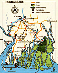 Discoveries of ancient civilizations excavated underneath the present is common news, but the find of older mangroves buried under the present, Sunderban of west Bengal is something unique. Dr. Sunirmal Chanda and his colleagues from the Center for Study of Man and Environment, Kolkata, India were awestruck to find material evidence from the drill core samples about the presence of ancient mangroves 30 to 50 meters below the present Sunderban. Their findings were published in the proceedings of the Fourth South Asian Geological Congress, organized by the Geological Survey Of India (GSI) in 2003.
09-Apr-2006
More by : V. K. Joshi (Bijji)
|
|
Thank you for your comment Nikil. I admire your observation. From the photos it is very difficult to postulate the period to which the pottery pieces belonged to. Still it will be useful if you can mail me a few pictures at joshi.vijakumar@gmail.com Bank of water body whether a river bank or the sea shore has fascinated the mankind since times immemorial. Sunderban is no exception. There have been several settlements there which were subsequently buried. The present ones may also meet the same fate. The burial doesn't take place over night, but as you have rightly observed the pots and shards do teel a tale that people did live there. With the sword of climate change hanging precariously over us-populations getting flooded will be in the news every day. That is why I keep on writing about such habitats which have encroached the banks beyond limits. |
|
|
Very interesting article. On a recent trip to the Sunderban(India), our boat steered very close to the shore during low tide and we saw in the mud many many pottery shards and whole pots(terra cotta in appearance) sticking out of the mud bank to a depth of about a meter and a half.I have no clue how old they could be or which period they belonged to.If you contact me I can mail you a couple of pictures that I took.Would be very interested to know more about the origins of those pottery washing away slowly but surely. |
