Jul 25, 2026
Jul 25, 2026
Avalanches always occur on the most beautiful spots on the earth. Uttaranchal Himalayas are no exception. Apart from being a trekker's paradise, some of the holiest Hindu shrines are situated here. Amongst these the Kedarnath is an amazing spot. Despite proximity to several avalanches the shrine has withstood the test of time. Several thousands devotees visit this place to pay obeisance year after year. While discussing the avalanches this story narrates how safe or otherwise is Kedarnath area. The pressure of visitors to Kedarnath has increased enormously and the need for the basic facilities like boarding and lodging has also proportionately increased. The shrine and the township around need an in depth survey to avoid mishaps due to avalanches. Kedarnath town and the environs have been studied in detail by the glaciologists of the Geological Survey Of India (GSI). Deepak Srivastava, Director and an eminent glaciologist has extensively explored the region for avalanches along with his team. 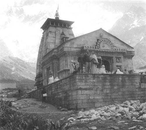
Much revered by the Hindus, the Kedarnath temple sits in the shadow of Kedarnath massif. Though constructed by human artisans the temple looks very much a part of the mountain eco-system. It is said that the temple has been there in some or other form even before the Mahabharata. Since 8th century the present temple has been majestically standing where it is and being worshipped.
The Mandakini River valley which houses the temple runs almost north-south, bound by five peaks, viz., 5505m peak, Bharat Kunta peak-6578m, Kedarnath peak-6940m, Mahalaya Paravat peak-5970m and Hanuman top peak-5320m. These form a sort of amphitheatre called as a cirque in the lingua of the glaciologists. A 5040m triangular peak, the Brahma Gupha juts out majestically in the middle of the cirque. The width of the valley in the cirque area (valley head) is six kilometer and narrows down to three kilometer in the southern end.
Srivastava in one of his papers says that the Mandakini River valley is unique because two glaciers that have separate regimen, orientation and flow occupy this single valley. The two glaciers, Chaurabari and Companion glaciers terminate at different elevations, at the same place. From the moraines it appears that these two glaciers were unified in the past and occupied the entire one kilometer wide valley at Kedarnath. Moraines are the rock boulders of assorted sizes to rock flour produced and carried by the glacier and left behind as they recede. These moraines are well established and held at place by the vegetation for a length of three kilometers up to the snout of the glaciers. The moraines have lots of stories hidden in them. It appears that there were at least four major episodes of glacier recession as marked by the traces of the moraines throughout the valley. In other words, earlier the glaciers had descended down to much lower levels than the present.
Kedarnath township is situated on a glacial outwash plain. Channels of Mandakini River originate from Chaurabari and Companion glaciers and encircle this plain to meet below the township. The erosion by the stream has been such that it has cut through the water table in the upper part of the plain. Thus constant oozing of water has made the place marshy.
Avalanches in any area depend upon several factors like the nature of the snow pack, physical and mechanical processes, slope conditions and geomorphologic setting. The last condition many times comes as a savior too. The geographical location of Kedarnath township is such that during the winters a single snow storm can precipitate up to two meters of snow. The density of fresh snow here is 0.01 to 0.02 gm/cc. The amphitheatre at Kedarnath many times creates a wind tunnel, raising cyclonic winds. Wind activity results in cornices and slabs. These slabs lead to slab avalanches. Windborne avalanches are often quite destructive. One such avalanche had uprooted micro-hydel generating unit and damaged the Bharat Sewashram building. While planning construction activity in air-borne avalanche prone areas protrusions in the path of the avalanche should never be allowed. They create the effect of a windblast and cause substantial damage.
A redeeming feature for Kedarnath is that the floor of the Mandakini valley in the area remains buried under ten meters of snow. The density of settled snow has been measured as 0.2 to 0.3 gm/cc by Srivastava and his colleagues. The temperatures below freezing point leads to a metamorphism of the snow and the grain size increases. Thus a crust of high density snow is formed all over that protects the structures buried therein.
The upper reaches of Mandakini valley are devoid of vegetation, except alpine grass. In the valley portion around Garurchatti, Rhodendron bushes and the area near Ghuinderpani have pine and birch trees. These barren slopes are not able to hold the avalanches and this part is maximum avalanche prone. Between the left morainic ridge and the wall of the valley runs a nala. This provides a good barrier against avalanches to the left side of the valley in Kedarnath township. The right side, due to absence of any such barrier is however, not so safe. The terraces formed by these moraines are fairly wide and people are tempted to start construction on both sides. But the right side should be left untouched warns Srivastava in his report. Moreover, the valley walls are very steep with flat portions at the heads which provide ample space for accumulation of snow. Generally such topographies do not generate regular avalanches, but if there is one it can be of high order.
The avalanches of Kedarnath area have been classified as Chute and Slope types depending on the nature of the zone of collection of snow. Genetically they develop as loose snow or slab avalanche depending on the climate and intensity of the snowstorm. The devastation caused by these is enormous.
Altogether 28 probable avalanche zones have been identified by Srivastava and his team mates situated between altitudes of 3800 to 4000 meters. One of them designated as R-13 has an average ice volume of 70891m3 with a chute length of 900m and impact force of 84.8tonnes/m3. Here it worth knowing that while an impact force of 10tonnes/m3 can uproot matured trees, an avalanche of 100tonnes/m3 can move reinforced concrete structures. Therefore the planners must always remember that there is no engineering solution against geohazards.
The temple has been safe from avalanches through the centuries. Even the present township of Kedarnath has not been hit by a major avalanche. An acute need for further expansion is being felt. For which the terraces on the left side only, up to Lenchuri village have been recommended by the glaciologists of GSI. Only drawback of this portion is the marshy condition due to deep erosion of the terrace. Development of a proper drainage can take care of the condition and habitats can be safely constructed.
The science of glaciology is much recent compared to the site of Kedarnath temple. Hats off to those saints who knew which is the safest spot for the shrine to remain intact for the centuries to come. Or was it the choice of the Lord Shiva himself!
15-Oct-2006
More by : V. K. Joshi (Bijji)
|
|
Yes Ajay, you are absolutely right. But we the people have encroached upon HIS territory with impunity and He has shown his Tandav...! |
|
|
Really it is beyond doubt that it is the choice of the Lord Shiva himself! |
