Jul 27, 2026
Jul 27, 2026
[To write this, inputs have been taken from many officers who faced the disaster and managed it. Noteworthy among them are Shri Vivek Kumar, IAS, Shri H.K. Dwivedi IAS and Shri Dipankar Chowdhury WBCS (Exe.) Jitendra Ray WBCS (Exec) has been of very great help in compiling and arranging the material]
Introduction
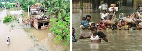
1. Floods are a regular feature in West Bengal. In the 29 years before 2000, the state had witnessed floods 21 times. However, the unprecedented floods in September–October 2000 will be remembered for decades to come. The intensity of the floods had surpassed even that of the landmark floods of 1978. All records of rainfall were broken. The water levels in all the major rivers in the Bhagirathi-Hooghly basin touched new heights. All roads, including the National Highway (NH-34) which connects South Bengal with North Bengal, were submerged. More than 21 million people were affected; about 2 million houses were damaged or destroyed and hundreds of lives were lost. Infrastructural losses were enormous. Bridges and culverts got destroyed at many places. There was devastation all around. The total estimated damage was about Rs.5660 crore, which is the highest for any single disaster in the state.
Location
2. The Deluge in 2000 happened mainly in the Bhagirathi–Hooghly basin and the basin area of Mathabhanga, Churni and Ichhamati. However, there was trans-basin flood spill that continued eastwards up to Bangladesh. The three most affected districts were Murshidabad, Nadia and North 24 Parganas. These are adjacent districts located in the eastern part of southern Bengal. The Ganga with all its tributaries covers all the three districts. The Ganga flows through the north of Murshidabad and at a point below Farakka bifurcates into two great distributaries: Padma and Bhagirathi. The former continues to flow eastwards through Bangladesh and ultimately falls in the Bay of Bengal. The Bhagirathi flows south bisecting Murshidabad. The rivers Mayurakshi and Dwarka join the Bhagirathi in the northern part of the district while the Messanjore Dam and Tilpara barrage are to its west. The Bhagirathi receives water from its left-bank tributaries like Jalangi and Churni in Nadia district. Flowing through all the three districts of Murshidabad, Nadia and North 24 Parganas, it finally falls in the Bay of Bengal at the famous confluence point called Ganga Sagar (Sagar island). The river Mathabhanga originating from the Padma in Murshidabad enters Bangladesh and after a long journey emerges in India at Gede in Nadia. After flowing for a few kilometers, it bifurcates into Churni and Ichhamati. The former flows in Nadia and falls into the Bhagirathi near Ranaghat. The latter travels for about 15 kms in Indian territory and then runs along the Bangladesh border. It re-enters into India a few kilometres above Bongaon and thereafter flows within India in Basirhat sub-division of North 24 Parganas district.
Cause of the Deluge
3. Rainfall had been erratic in 2000. Towards the end of the monsoon there was incessant rainfall in the 3rd and 4th weeks of September 2000 not only in these districts but also in the upper catchment area of Bihar, Jharkhand and North Bengal. The accumulated water posed severe threats to reservoirs, dams and barrages in the region. From 18–23 September, Murshidabad alone received 1200 mm. of rain in addition to its annual quota of 1500 mm. The Mayurakshi catchment area upstream of Messanjore Dam received 1008 mm rainfall in 96 hours from 18 to 22 September, which remains a record to this day. All the major rivers were flowing above their danger levels by 19th September and the low-lying areas were already inundated. There was waterlogging in most areas, rural and urban alike. Discharge of water from barrages under compelling circumstances was the last nail in the coffin. The water level of Bhagirathi-Jalangi at Swarupganj (Nadia) was 9.61 mtr on 20.9.2000 (Danger Level 9.05 m.) after the Tilpara Barrage released nearly 1.5 lakh cusec of water followed by another release of 1.2 lakh cusec.
4. The following tables give an idea of the rainfall and the discharges from the Tilpara barrage and the Massanjore dam:
Table - 1: Rainfall (in mm.)
| Places | Date | ||||
18.9.2000 |
19.9.2000 |
20.9.2000 |
21.9.2000 |
22.9.2000. |
|
Berhampore |
140.00 |
558.80 |
471.20 |
92.10 |
25.40 |
Kandi |
30.00 |
332.80 |
250.0 |
65.00 |
N.A |
Bharatpur |
32.00 |
210.00 |
230.00 |
N.A |
N.A |
| Salar |
57.00 |
393.00 |
330.00 |
58.00 |
N.A |
Table - 2: Volume of rainfall in catchment areas (18 to 21.9.2000)
Name |
Catchment area (in Sq. Km) |
Volume of rainfall in Catchment areas (in Lakh acre-feet) |
Pagla-Bansloi |
2200 |
20.81 |
Brahmani-Dwarka |
3446 |
32.59 |
Mayurakshi (upstream Massanjore) |
1860 |
15.17 |
Mayurakshi Massanjore to Tilpara) |
1349 |
12.62 |
Mayurakshi (Tilpara to Babla) |
1900 |
9.20 |
Ajay |
6000 |
38.87 |
Jalangi |
4300 |
27.67 |
| Total | 21055 |
156.93 |
Table - 3: Discharge of water from Tilpara and Massanjore
| Date | Tilpara Rate of discharge (in cusec) |
Massanjore |
|
Rate of discharge (in cusec) |
Total Discharge (in acre-feet) |
||
18.9.2000 |
1,09,284 |
99,471 |
45,831 |
19.9.2000 |
1,47,991 |
1,27,918 |
2,25,346 |
20.9.2000 |
1,25,925 |
1,28,550 |
2,34,939 |
21.9.2000 |
2,46,000 |
2,00,500 |
3,22,403 |
22.9.2000 |
1,44,180 |
1,87,839 |
5. It has been estimated that a discharge of more than 4.5 lakh cusec passed through the Bhagirathi against its carrying capacity of 1.05 lakh cusec. Again, more than 1.5 lakh cusec of discharge entered into the Ichhamati-Churni system. The carrying capacity of Ichhamati is at the most 20,000 cusec. The consequences were obvious– the most devastating floods in the history of West Bengal.
The Beginning and Progress of the Disaster
Murshidaba District
6. On 17th September there was heavy rainfall in catchment areas of the rivers Pagla-Bansloi and Brahmani-Dwarka thereby flooding them. At midnight Vivek Kumar, the District Magistrate (DM) –who had joined only on 6th September—received information from his counterpart at Birbhum that the Tilpara barrage was overloaded and had to evacuate some of its excess water immediately. He said water would be released at the rate of 40,000 cusecs. The DM immediately called the Superintendent of Police (SP) and the Subdivisional Police Officer (SDPO) Kandi sub-division. He posed the problem of how to inform the populace about this huge volume of water rushing in from the west. The SDPO left his residence immediately and, in the absence of any public address system, used the loudspeakers atop the mosques to start what became a relay transmission, from one mosque to another, telling the people of the impending danger. But, to the DM’s dismay, none was willing to voluntarily move from his home.
7. By the evening of 18th September it had rained 120 mm. The midnight call from DM Birbhum came again, this time intimating that the rainfall had further exacerbated the reservoir position in the Tilpara barrage and that this time they had no option but to release water at the rate of 75,000 cusecs. Besides this, there was no let-up in the rain; the skies had opened up. Reports were coming in that massive precipitation was going on over a large area covering thousands of square kilometres in Bihar, Jharkhand, and North Bengal. The water had to flow south and east: Murshidabad was going to receive all these millions of cubic metres of water! From 18th to 23rd September 2000, the district received 1200 mm. rain.
8. By 19th September this flood water reached the Bhagirathi. The rainwater of the entire catchment area of Pagla-Bansloi entered into the Bhagirathi through Pagla river near Jangipur and through Kharkhari river near Mirzapur. The entire area including Raghunathganj town, the sub-divisional headquarters, was flooded.
9. On 20th September waters of the Bansloi spilled over its eastern bank and hit the feeder canal from west. Ultimately it crossed the feeder canal and, flowing across the National Highway, flooded Suti-I & Suti-II Development Blocks. Floodwaters of Pagla-Bansloi coupled with the local rainfall inundated vast areas of Raghunathganj-I, Raghunathganj-II and Lalgola Blocks.
10. Berhampore town, the district headquarters, was inundated due to heavy rains and the Indraprastha area faced the highest inundation as this was earlier a part of Bishnupur Beel (lake). Floodwaters of Bhagirathi overflowed its eastern bank, flooding Lalbagh, Domkal and Sadar sub-divisions. Around 20th September the possibility of the flood waters entering the town arose. From Gorabazaar to Haridasmati, river water started spilling over its left bank. Minor breaches occurred at different places but devastation could be avoided by patchwork repair using gunny-bags filled with sand/mud. However, as the drainage system was obstructed as a result of widespread indiscriminate constructions in the outskirts of the town, floodwater took more than a week to recede.
11. From Bhagwangola to Plassey there is a 90 km. long embankment along the left bank of the Bhagirathi. From the morning of 20th September till the night of 21st September, this embankment was breached in 82 places. The total length of the breach was 5061 metres. The breaches at Kalukhali, Mahula, Mayaampur, Dadpur, Lokenathpur, Rampara, etc. caused heavy devastation.
12. Kalukhali is a village in Bhagwangola–1 Block on the left bank of the Bhagirathi where the embankment and State Highway-12 run side by side. The embankment here is 1.7 metres high and even in 1999 flood waters did not spill over here. Floodwaters of the Bhagirathi reached the place on 20.9.2000 and in the morning of 22.9.2000 it started spilling over the embankment. Efforts made to contain the water by placing gunny bags full of earth and sand failed and at 9 P.M. a 152 metres long portion of the embankment was breached, washing away the State Highway. It took heavy toll by destroying a number of houses and even washed away the railway line near Subarnamrigi railway station and flowed with a heavy run-off along the channels of Gobranala and Bhandardaha till it reached Jalangi after traversing a 50 mile long course. The name Kalukhali became a symbol of devastation.
13. Mayaampur is located within Beldanga-I Block where the embankment last broke in 1978. On 19th September, the water level was 2.5 meters below the embankment. On the morning of 20th September water started overtopping it and at 8 A.M. 197 metres long portion of the embankment was washed away, damaging N.H 34 and the railway line, resulting in high inundation of the whole of Beldanga-I Block and part of Hariharpara block. The Bhagirathi had breached its embankments in many other places the same day because the run-off of Dwarka-Babla from the west hit the Bhagirathi directly at that time.
14. Rivers in Kandi Sub-division ran in high spate. Water rushed through the narrow navigation canals washing out the embankments that fell in their course. Vast areas of the sub-division were inundated. Rainwaters of catchment areas of Santhal Parganas and Birbhum were carried downstream by hill freshets (fast flowing streams originating in the Chotanagpur hills). This run-off of rainwater added to the inundation of all blocks of Kandi sub-division, Nabagram Block of Lalbagh sub-division and the western part of Beldanga–2 Block of Sadar sub-division. Finally, when it reached the Bhagirathi the situation became worse as this river was already full to the brim. This caused a backflow in the western tributaries of the Bhagirathi resulting in stagnation of water in the areas west of it.
15. A breach occurred in the left bank of Mayurakshi river in Birbhum and these floodwaters entered the Kana Mayurakshi whose carrying capacity was 1/10th that of the Mayurakshi. Naturally, the Kana Mayurakshi could not contain the heavy flow, which resulted in further inundation of Burwan and Kandi.
16. On 19.9.2000 Kandi-Gangedda embankment was overtopped by a 2-4 feet high surge of floodwater and 5-10 feet high water ran across Kandi-Berhampore road. Kandi Laharpara bandh, and Indodangapara bandh along the left bank of Kana Mayrurakshi and embankments at various places over the right bank were also breached, resulting in flooding of the entire Kandi sub-division including Kandi town.
17. Rains in the catchment area of the Brahmani, a flow of 80,000-cusec water from Baidhara Barrage [near Mallarpur in Mayureswar -I block in Birbhum district] and uncontrolled discharge of water of the Tripitar [in Birbhum district] incapacitated the Brahmani from containing floodwaters in her channel. Further, the right afflux bandh of the Dwarka Barrage at Deucha [in Birbhum] broke in the evening of 18.9.2000. These two rivers meet at Sankoghat in Murshidabad and downstream the Gombhira falls into it. The huge flow of flood water of the four hill freshets [originating from the Chotanagpur hills] caused devastation in Nabagram, Khargram and Kandi. Finally, these flood waters reached Hijol along their usual course causing breach of embankments on both the sides, washing away metal roads that fell in their way.
18. The flood waters that flowed along the channels of Kopai, Bakreswar [in Birbhum] and their combined stream Kuiya [the confluence point being at Labpur in Birbhum] swept away embankments at a number of places. The embankments along river Bele (a branch of Mayurakshi) got breached at several places on 19.9.2000. The result of these was inundation and devastation in Khargram, Burwan, Kandi and Bharatpur blocks of Murshidabad district.
19. A vast area of about 5,000 sq. km. covering 29 blocks and 5 municipalities of the district went under water.
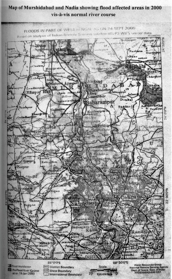
Nadia District
20. In Nadia district it began with a breach in a brick embankment at Fulia-Boyra near Krittibas Library in Ranaghat Sub-division on 19.9.2000. An electric pole was ordered to be disconnected to prevent electrocution. A few families were reported to have been affected. Events thereafter occurred thick and fast. Bablapara and Nutangram under Haripur G.P in Santipur were flooded and people in those areas were requested to shift to safer places. The Ranaghat –II block office got submerged. The Block Development Officer (BDO) who had taken charge of the block only on 25th August 2000 somehow managed to save a typewriter, an issue register and some papers with which he went to the Nokari Gram Panchayat (GP) and set up his office there to conduct the emergency operations.
21. The BDO Kaliganj reported a breach in Serakhali point in Jagatkhali Embankment inundating nearby areas, e.g. Matiari, Juranpur, Gobra, Faridpur, Hatgachha, Rajarampur, Ghoraikshetra, Palitbegia. The BDO Office was partly submerged and police posting was required there. Debagram R.O.P. [Rural out-post] was affected. Debagram, Paglachandi, Molandi, Mira-Plassey, Char Chuadanga areas were inundated on 19th September.
22. I, as Commissioner, Presidency Division, arrived at Krishnanagar on my way to Berhampur on 19th September and took stock of the situation. I was compelled to return to Krishnanagar as the road from Plassey onwards was submerged. On the way back I cleared flood victims squatting on NH-34 near Bethuadahari, holding up long-distance buses and lorries, by talking to them and arranging for despatch of relief.
23. On 20th September the Serakhali point of Jagatkhali embankment was damaged and the office of the BDO Kaliganj was almost submerged. The officers and staff had to shift to the BLLRO’s (Block Land and Land Reforms Officer) office there. The BDO sent an SOS stating that all communications had been disrupted. A breach occurred in Gokhurapota Bundh near Brittihuda Gram Panchayat in Chapra Block. Executive Engineer, Irrigation & Waterways, tried to protect it temporarily with gunny bags.
24. The water level of Bhagirathi-Jalangi kept rising. It was 9.61 m on 20.9.2000 (Danger Level 9.05 m) at Swarupganj. Vast areas of Prachin Mayapur and Nabadwip got inundated. BDO Nabadwip who was on leave and holidaying in the hills far off, heard of the floods and hitched a ride on top of a truck to reach Krishnanagar. He met the DM and the Divisional Commissioner. As Nabadwip was inaccessible, he was asked to run the Block office locally in Krishnanagar till the situation improved.
25. Vast areas of Santipur, Tehatta I & II and Kaliganj were submerged or disconnected. Road communication was disrupted severely. Two trucks carrying relief materials bound for Murshidabad could not reach the destination. Only two out of seven trucks bound for Krishnanagar could manage to reach. Speedboats, country-boats and even trawlers were used in Santipur Block to rescue and shift the affected people.
26. On 21st September, the Executive Engineer (Irrigation & Waterways) informed the District Relief Control (DRC) that the Bhagirathi would overflow its banks and the river Churni was likely to spill over. Breach of Tarapur embankment [in Ranaghat-I block having border with Santipur block] was imminent and the extent of damage would be unprecedented. The Subdivisional Officers (SDO) were immediately informed of the impending danger. The Duty Officer (Wireless) reported that breach of Chulkani embankment in Chapra was likely. The embankment ultimately gave way and all attempts to save it went in vain. The water-level rose rapidly, and the entire Chapra Block was in danger of being severely inundated.
27. Meanwhile, floodwaters started entering fresh areas of Deypara and Ruipukur Gram Panchayats in Krishnanagar–1 Block at midnight. People of these areas had never seen floods before and were in panic. The BDO tried his best to procure boats but without any success. [Govt. had ordered booking of boats in every block, but no boats were to be found though booked. One of the reasons for this was that past dues were still pending with the government for payment. Further the government’s rate was much less than what a boatman could earn daily in such a situation.] The Pradhans of those GPs came to the BDO early next morning and broke down requesting him to do something to save the marooned people. The BDO contacted the DRC and after a lot of persuasion managed to get two speedboats from the Water Wing of Civil Defence (CD) for rescue operations. The CD staff rendered yeoman’s service in saving lives of the flood victims. Inundation continued in Krishnanagar-1 and Chapra Blocks.
28. Krishnanagar town was threatened by the rising water level of the river Jalangi. On 22nd September, the embankments had to be raised by about 2.5 feet by stacking up sand bags overnight. But all was in vain as the river water entered the town, overtopping the National Highway. The electricity sub-station at Krishnanagar got affected and power supply had to be disconnected. Telephones had ceased to function in some parts of the district and the road communication system was choked.
29. All the 17 blocks and 10 municipalities of the district were under the grip of flood by 25th September, inundating Asannagar hospital of Krishnanagar-1 Block, several Block offices like Nabadwip, Kaligunj, Ranaghat-1, Ranaghat-2, Shantipur, Hanskhali, Tehatta-1, Tehatta-2, Ranaghat Jail, Kalyani Central Park and FCI godown at Kalyani, office of the SDPO and the Circle Inspector (CI) Kalyani, the Court at Kalyani, part of Iswar Gupta Setu (bridge) and many other offices and school buildings as well as the infrastructure of public utilities. Paglachandi railway bridge was washed away on 25.9.2000, cutting of Kaliganj from the rest of the district. Murshidabad also got severed.
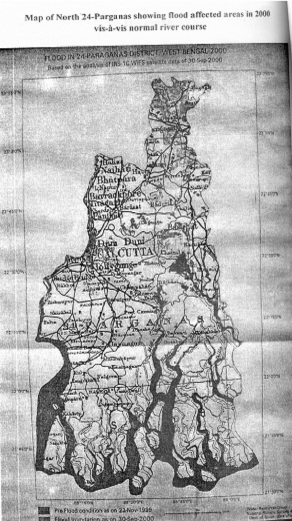
North 24 Parganas District
30. Hari Krishna Dwivedi was the DM. Owing to merger of flood spills in different basins there was transfer of flood discharge from one basin to another. The flood spill of the Bhagirathi and Jalangi rivers entered the basin of Mathabhanga, Churni and Ichamati rivers. The huge discharge that entered Ichhamati exceeded its carrying capacity by far and spilled over both banks of the river inundating a vast area of Bongaon, Basirhat and parts of Barasat sub-division. The vast sheet of water travelled at high speed causing breaches in the embankments on both sides. It washed out 5 km. of flood embankment in mouzas Nalbon, Banglani, Faridkati, Kulia, Deepmedia and Kankrasuti of Bagdah Block. There were slips, erosion, bank failure etc of the Ichhamati in many places in Swarupnagar, Baduria, Basirhat-1, Hasnabad Blocks and Taki municipality causing widespread flood in these areas.
31. The Jessore Road [which connects Bongaon subdivision and Bangladesh with Barasat] remained inundated for many days. It became totally unfit for traffic movement beyond Gaighata bridge and road communication with Bangladesh had to be kept suspended for a number of days. The road bridge over Ichhamati at Bongaon was totally damaged. The Basirhat-Baduria-Swarupnagar Road remained under 7 to 8 feet of water. The full moon in the 2nd week of October 2000 retarded the recession of flood water.
32. More than an area of 960 sq.km. was affected causing damage to or destruction of 2,65,000 dwelling houses both in rural and urban areas. There was huge loss of standing crops, school buildings, railway tracks, bridges, culverts and public utilities. 47 valuable human lives and innumerable lives of cattle and pets were also lost.
Continued to Next Page
24-Oct-2020
More by : Dr. Pradip Bhattacharya
