Jul 27, 2026
Jul 27, 2026
Far flung seven states of northeastern India , viz. Meghalaya, Assam , Arunachal Pradesh, Nagaland, Manipur, Mizoram and Tripura are fondly called as seven sisters. These states are divided into 72 districts, 412 blocks and 41240 villages. Tea, hydrocarbons with a gas potential of 30 billion cubic meters of natural gas and Timber are the mainstay of the economics of the area. The turbulent rivers of the region hold a promise of generating 50000 megawatts of electricity.
Despite such rosy projections these states have their own geo-hazards like landslides which hamper the growth.
It is a coincidence that politically sensitive and insurgency prone J&K and the northeastern states are geologically sensitive too. The present problem of these states is the human attrition. In the geological past these areas experienced a violent collision between two landmasses which made them geologically sensitive.
Close your eyes and try to visualize the geographical map of India. The Himalayan arc takes two distinct sharp turns. One is near Gilgit north of Kashmir and the other on the northeast at Shillong plateau. This bend of the Himalayas is due to the collision of the Indian Plate with the Asian Plate some 20 million years ago. The collision still continues and makes these two areas geologically sensitive. In other words these areas are tectonically active.
It is common experience that the slope forming material gets more weathered in tropical climate. Northeast India is a classic example of tropical climate, high rainfall and dense foliage. The last of the factors is however, under great stress due to indiscriminate felling of trees to make room for the houses. Apart from human efforts in reducing the forests, the nature too has uprooted trees in the past during earthquakes.
Guwahati, the district headquarters of Kamrup in Assam , is the gateway to the seven states. It has a crucial role in the economic, industrial, commercial and educational development of entire northeast region. The gargantuan population pressure has hit Guwahati too. The plain areas are now jam-packed. People are trying to construct dwellings on the surrounding hill slopes.
In a hilly terrain the slopes remain in a state of balance as long as they remain undisturbed. It is also a fact that the network of roots of the trees bind the soil and check downward movement of the lose soil. Construction of a house on a hill slope not only demands a clearing but also flattening a portion by cutting a wide terrace. The activity immediately disturbs the angle of repose of all the material lying on the slope. Gravitational pull aided by water makes rocks, lose soil etc slide down.
The first major landslide of Guwahati city took place in Nabagraha area in 1972 says Ranjana Borah of department of Geological Sciences, Gauhati University , Guwahati. This was followed by other major slides in Dhirenpara, Dispur, Kacharibasti, Rupnagar, Madgharia, Sarania, Kalapahar Colony, Bazar Hillside, Kharguli etc. The list clearly shows how things have deteriorated between 1972 and today.
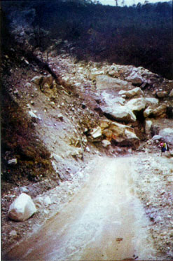 Landslides are sudden and swift in Guwahati. Rock mass or soil cum rock mass suddenly moves down, particularly during the monsoon. Other reason for such movements is due to lack of drainage or blockade of drainage by human agencies. It is common practice on hill slopes to provide adequate drainage. If an outlet is denied water enters the weathered surfaces and attempts to come out by generating pore pressure. The sudden movement of slope forming materials is due to this pore pressure.
Open joints in rocks are lucrative for water to enter and saturate the rocks. Dispur, Kacharibasti, Nabagraha, Dhirenpara and Rupnagar areas in Guwahati have such rocks. Abetted by anthropogenic activity rocks in these areas get disturbed and during rains become a nuisance by their sliding.
A study carried out by Geological Survey Of India (GSI) is that Assam is prone to landslides and Guwahati is one of most sensitive areas for the hazard. Between 1985 and 2000 more than 70 persons have perished in landslides in this area says the study conducted by S.Chopra and V.C. Srivastava of GSI. The incessant rains of 2004 took away 11 lives and more than 80,000 people were rendered homeless.
Roger Bilham a renowned seismologist from America , based on his observations on the trends of earthquakes, he postulates a major earthquake for Guwahati area. In the eventuality of a high magnitude earthquake, landslides are inevitable. Dr. Arvind Sinha of GSI has calculated that seismogenic landslides in the past dislodged approximately 1.505 X 10¹⁰ m3 of material successively in 1897 and 1950. Such mass wasting process is not only hazardous for the habitats but also for the mighty Brahmputra River. In one of his essays, Dr. S.R. Joshi of Centre for Science Education, NE Hill University, Shillong says that the Brahmputra carries one of the highest sediments loads in the world, about 332 million metric tonnes annually throughout its course. Recent satellites photograph reveal that Brahamaputra is continuously shifting southwards and in some places, may be migrating at rates as high as 800 m/yr. The shifting of the river is distinctly evident in the districts of Dibrugarh, Morigaon and Sonitpur, where the river has already shifted 2 to 8 km. in the last ten years.
A shifting river erodes the toe of the slopes, which leads to landslides.
A number of corrective measures have been suggested by the geologists and the engineers involved in geo-technical studies of such slide prone areas. Most significant of these is development of a surface and subsurface drainage system for areas like Guwahati. The drainage has to be so effective that rain water is prevented from entering the affected areas. In the areas prone rock falls benches constructed on the slope collect rocks or boulders and prevent their rolling down the slope. Bitumen or asphalt material can be used to seal the gaping joints of rocks to prevent entry of water. Breast Walls or Retaining Walls are normal convenient methods of checking landslide along roads.
The Border Road Organization (BRO) has successfully used 'Geo-textiles', a tough and resilient fabric indigenously made of jute. The fabric acts as a binder for the soil and holds it. V.K. Yadav a Chief Engineer with the organization developed this novel method of growing bamboo seeds under the cover of jute geo-textile. Bamboo shoots sprouted through the textile cover and the roots gripped the soil to prevent soil creep. The BRO has also locally placed high resolution satellite cameras to record movements if any on the hill slopes. Such measures have been successfully used elsewhere in the World and the results have been encouraging.
Technologically we are on sound footing as far as the landslides are concerned. Landslide Hazard Zonation Maps are available, people can chose safer areas for construction of habitats. However, social awareness needs to be carried out on war footing. Engineering solutions can not stop the Himalayas from rising and as such landslides will remain inevitable. A strict enforcement of rules by the government and an active participation of the society to avoid hazard prone areas will save many a lives
19-Nov-2006
More by : V. K. Joshi (Bijji)
