Jul 27, 2026
Jul 27, 2026
 The Indian rivers have feminine names with the exception of Brahmaputra, meaning the son of Brahma in Sanskrit. Brahmaputra is amongst the largest rivers in the world with a total length of 2880 km from its origin at Jima Yangzong glacier near Mount Kailash in Tibet, the land of mystique, till it meets the sea in the Bay of Bengal. Out of its total length the river flows for 918 km in the Indian territory. After its origin the river flows for nearly 1700 km in the Himalayas at an average altitude of 4000 meters and is thus highest of the major rivers of the world. At its easternmost point the river bends around Mount Namcha Barwa and forms Yarlung Tsangpo canyon which is considered deepest in the world.
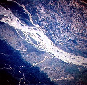
Brahmaputra is a unique river. It is known by different names in different places. Known as Tsangpo in Tibet, the river is called Siang in Arunachal Pradesh. From here the river descends rapidly and as soon as it enters the plains it is called Dihang. After flowing for about 35 km in the plains the river is joined by two more rivers, Dibang and Lohit. Thereafter it becomes the Brahmaputra River . In Assam the river again bifurcates between Dibrugarh and Lakhimpur in to Kherkutiya and Brahmaputra channels. These meet again 100 km downstream. The area in-between the two is known as the Majuli island. In Assam the river is just 80 km wide says K.V. Venkatachary of the Indian Space Research Organization (ISRO). Venkatachary and a team of experts constituted a task force to study the 1998 disastrous floods in Brahmaputra. After a thorough study they published a research paper suggesting a space based Disaster Management System for the river.
 Brahmaputra is unique in one more way. It flows through different geographical terrains. While in Tibet the River flows mostly through a plateau. After entering Indian territory it passes through the mountainous terrain and then the wide plains. As soon as it reaches Assam between Kobo and Dhubri about 20 significant tributaries join the river on the north bank and another 13 on the south bank. The major rivers joining the north bank from Arunachal Pradesh are Subansiri and Jia Barail. Again a major river joins Brahmaputra's south bank, Dihang from Arunachal Pradesh. Dhansiri from Nagaland, Kapili from Assam join the south bank of the River.
As the river reaches closer to the Bay of Bengal , the drainage area is subjected to cyclonic storms. Brahmaputra is one of the few rivers of the world that exhibit a Tidal Bore. Brahmaputra River valley is generally a narrow valley with steep slopes. The river catchments get the highest rainfall (mean annual: 2300 mm). Deforestation of hill slopes and unsustainable agriculture practices aided by heavy precipitation augment the denudation process. Thus Brahmaputra carries the heaviest sediment load amongst the Indian rivers. The sudden change of gradient upon entering the plain changes the river hydraulics considerably. Thus the stream gets bogged down in its own sediments and the net result is recurrent floods. Floods are also aggravated by rampant earth cutting and road building activities all over. The silted channel can not cope up with the onslaught of increased discharge during monsoons and the banks spill over.
It is known that the Himalayas are there as a consequence of the great collision between the floating Indian landmass and the stable Tibetan Plate some 20 million years ago. A peculiar feature of the Himalayas is that near Mount Namcha Barwa they take a sharp southerly bend. This indicates that the area has faced a greater impact of the collision. Since the Indian Plate is still in the process of collision this area shakes frequently. All such recent events are placed under the category of neotectonism by the geologists. Some recent studies by the GSI in Pagladiya-Phutimari-Jiabar sub-basin (p-p-j sub-basin) of Brahmaputra reveal that there is a constant interaction between the riverine processes and the neo-tectonism. As a result of which the channel frequently oscillates and shifts in this sub basin. End result is greater recurrence of flash floods in p-p-j sub basin compared to other areas. The experts of GSI therefore recommend that a detailed neo-tectonic study of Brahmaputra basin is essential to work out a solution for the flood disaster.
Floods in Brahmaputra bring the additional problem of erosion. As per a report of the Centre For Science and Environment more than ten lakh Hectares (ha) of land has been eroded in Assam; followed by 8.15 lakh ha in Meghalaya; 5.08 lakh ha in Nagaland; 1.08 lakh ha in Tripura and 0.14 lakh ha in Manipur due to erosion by water. In the Brahmaputra catchment the rate of erosion is estimated to be 953 ton per sq km per year, the highest in any catchment in the world. Brahmaputra and Barak Rivers and their tributaries have eroded thousands of hectares of precious land in the past three decades.
To add to these problems is the population boom and tendency to settle down on the flood pathways. Human beings have been settling along the rivers since times immemorial. Indus Valley civilization is the classic example. The recent tendency is to 'develop' any flat ground irrespective of its location. Encroachments on the riverine tracts lead to constrained waterways and increased sedimentation. The Ox-bow lakes and dry, old courses of the rivers are also not spared. They are filled up to accommodate housing schemes. Normally such features act as shock absorbers during initial floods. Net result is increase in the fury of the floods. The flood affected areas have increased three times since 1960 and the total damage incurred each year through floods is now six times than that incurred in 1950s. The figures are quite alarming as per a World Bank Report (2006) published in November, 2006 by Himanshu Thakur of South Asia Network on Dams, Rivers & People, Delhi. The flood damage trend in Brahmaputra Basin as per the report has risen in terms of monetary losses from Rs 58.6 million in 1953-59 period to Rs 7171.7 million in 1999-2005. While in the former period only 0.86 million people were affected in the later 4,586 million people faced the vagaries of floods. A crop area of 8.85% was affected in 1953-59. The percentage rose to 35.06 during 1999-2005 period.
The irony is that the fertile plains we have in our country are an aftermath of floods only. And it is due to floods only that the soils are 'recharged' each year. The impact of floods on habitats has considerably increased. But one need not blame the rivers or the nature alone for the hazard. It is the society which should take the onus of the misery due to floods. If people stop settling down along the rivers, if the governments take precautions while constructing roads or taking up other such developmental issues in the narrow river valleys, half the problem of floods can be solved. For the remaining we need more flood forecasting stations, better communication network and an alert Disaster Management Force. The constitution of Disaster Management Authority by the government has been a very positive step in this direction.
We are on this Earth because of water. With water, floods are inevitable. We need the space to live, and grow and we also need water to survive. Naturally better flood protection measures are the need of the hour. We shall read about some in the next issue.
17-Dec-2006
More by : V. K. Joshi (Bijji)
|
|
Thanks for your comments Dr Kakati. Am sorry I have not been able to follow up the progress made in the direction of flood protection in the region-since I wrote the piece. Flood protection is a very vital national issue, provided our leaders accept it as that. More than half of the problem can be solved if the land sharks are not allowed to usurp the land on the flood pathways of the rivers and palm it off to gullible masses. I agree we do need land to build habitats, but then why select the river fronts only! |
|
|
Very informative account. In view of what you have said, do you not think that the flood management of the Brahmaputra basin should be treated as a very important national problem and appropriate priority action is taken by GOI? What is the progress on all fonts since you wrote this article? |
