Jul 08, 2026
Jul 08, 2026
Gohna, a fallstruz lake, with a spectacular dimension, existed for 77 years with the people of Gohna (Durmi) village, in district Chamoli, Uttarakhand, It was formed in 1893 due to the blocking of the Birehi Ganga, a stream joining river Alakhnanda, the main tributary of river Ganga in the mid-reaches of Uttarakhand due to a huge mountainous landslide. The author visited Gohna lake in October 1968 to survey the area for medicinal herbs and also studied the topography of the lake and its surroundings. In the year 1970, the lake was completely swept away due to very incessant rains in the upper valley of river Birahi that had causing a forceful flood and that had caused a considerable loss of human and animal lives and property.
In the present article, the status of the Birahi valley, in prehistoric times; the geological history of the lake Gohna from 1893-1970, its topography, the account of the breaching of the lake water in 1894, and the management precautions and efforts made then, to save the life of the people and property and subsequently, the disaster caused, due to bursting of lake in 1970, with huge loss of human and animal lives and the property is described.
The Existence of the lake from 1894-1970: The Gohna lake lay in the East-West direction. On the eastern side, there was the silted mouth of the lake from where the Birehi river entered into the lake, below the Deldhunga hill. On the West, there was a wooden bridge constructed, to cross the outlet of the lake water, which one had to cross to reach Durmi village and the Forest Rest House at Gohna. Hariadeep, a high hill (8500 ft. or 2590.79 m.) with its prominent deep scars left due to the broken portion, in 1893, were quite visible. On its opposite, was seen the Maithana hill. On the right flank of the lake is the Kitchmoli hill (about 7,000 ft. or 2133.59 m.).
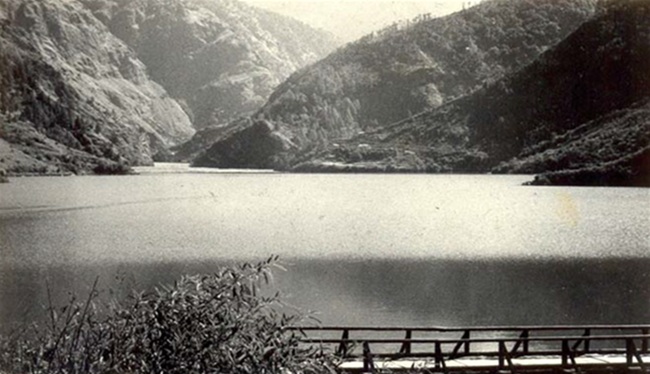
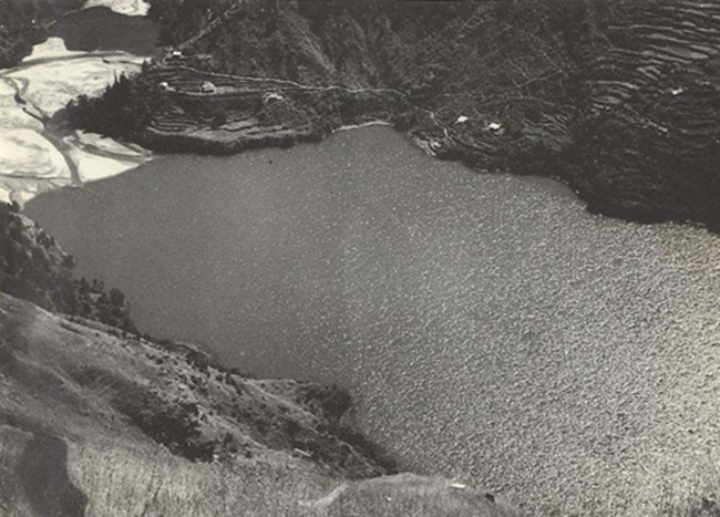
View of the Gohna lake from the entrance, a wooden bridge had existed over the outlet of the lake water, to reach Durmi village and to the Forest Rest House. 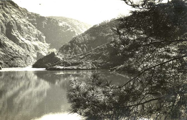
Another view of the lake from the end of the bridge.
The Geological history and the formation of the lake:
Before 21st September 1893 the Birehi used to flow freely in this open valley, as it is flowing now. On 21st September 1893, a huge portion of rock, estimated to be 1000-1200 cu.m. broke from the right portion of Hariadeep hill, with a thunderous noise, reaching down to the base of Maithana hill, thereby blocking course of the river Birehi and forming a dam. An enormous dust cloud was formed, which spread slowly up to Chamoli, the then district HQ and to Karnprayag. This dust storm lasted for 3 days completely hiding the sun. A thick layer of dust covered everything on the ground.
Day by day, the water level of the dam began to rise for an year and until August 24, 1894, a vast dam nearly 4.2, km length, 0.7, km width and 150, m. in depth, was in existence.
The then, government of United Provinces (now Uttar Pradesh) under the British rule was much worried to imagine the consequences, if this dam burst out. The flood- disaster would cause great havoc right up to Rishikesh and there would then be a great loss to property and life. Consequently, elaborate precautions were immediately undertaken just after the formation of lake to face the disaster.
The Management and precaution undertaken:
When the news of the landslide, and the blockage of river Birehi reached Chamoli, the then, district HQ., the officers concerned rushed to the sight of occurrence. The following measures and precautions were undertaken on war footings, (Pulford, R. R. et al., (1894).
Prediction on the bursting of the newly formed lake: Based on Lt. Crookshank's data, the army engineers had very accurately predicted the date when the overflow would occur. On 22 August 1894, nearly 11 months after the formation of the lake, Lt. Crookshank declared that the flood would start in the next two days. True to the prediction, the river topped the dam in the midnight hours of the 25th of August, and the barrier collapsed with a bang; the flood lasted only for six hours and ended early in the morning, on the 26th August 1894.
The Bursting of Dam:
Fortunately, within a few days before the burst, authorities had been able to evacuate the entire valley completely. It was estimated that 10,000 million cubic feet of water flowed into the valley. The escaped water caused much damage to private and public property. The lake flood rose into the Birehi valley up to 84 meters though, its height rapidly decreased, when the valley widened. The river Birehi swept away all the nearby fields, trees, houses, etc. However, down below the beautiful city of Srinagar ( Uttarakhand) was completely wiped out including the old palace of the city, where once, the Moghul prince Jehangir had taken refuge. It is amazing that only the Kamleshwar temple was left out. The present Srinagar city is established second time. But remarkably, there was no loss of human lives except a family of a fakir, who despite several warnings did not leave his dwelling. The total loss to the public property was estimated to be less than Rs. 95,000, in 1894.
In the history of flood disaster management, it was regarded as one of the most proficiently and successfully handled cases, in which there was not a single loss of life. Everyone was well informed about the incoming danger, and people were taken to safer places.
The Gohna Lake:
After the dam got burst, the water left behind in the form of a lake and was to be known as Gohna lake. When the people of Durmi village awoke on 26th August 1894, a lake of about 3.2 km. in length and 0.7 km. wide and about 40 meters deep, which covered an area of 400 acres, and remained with them for another 77 yrs. However, the army engineers created a safe passage for the Birehi Ganga, so that there was no danger from any further bursting of the lake and the danger of flood havoc.
The Geology of Birehi valley:
The Birehi valley is of great geological interest. According to geologists, Heim and Ganseer (1939 p. 51, in Central Himalaya), there had been a similar mountain slide, to the west of Gohna lake, probably in prehistoric times. The landslide had not only dammed Birehi valley but also filled the mouth of the valley on the opposite side of south of Gohna lake.
They further wrote that In the Birehi valley, there existed a small lake about half a mile long ( 0.80 km) in one of the feeders of Birehi river. In 1868, a landslip occurred and the fresh dam, as well as the portion of old one, which was known as Gudiyar lake, gave away. A serious flood also resulted in river Alakhnanda. At that time, no less than 73 pilgrims, who were resting at Chamoli Chatti (Pilgrim's huts) were washed away. Now, Gudiyar lake is no more and the lakebed is filled with shingle and debris, like the present remnants of Gohna lake at Durmi village.
Scientific and Geological Research: The incident of formation of Gohna lake was of remarkable geological interest and scientifically important. Within three months after the catastrophe 3 papers were consequently published in Nature, the world foremost scientific journal, viz., August 30, p. 428, and September 20, p. 501 and October 18, p. 596, 1894.
Not only in 1894 but also the catastrophe of 1970, the geologists of many countries visited the place to examine and analyze the geomorphological, geotechnical, geohydrological, tectonic, sedimentary and climatic data.
Types of Lakes:
According to Albert Heim, there are 20 types of geological lakes. Lakes like Gohna are categorized under the Fallstruz lake, which means lakes formed due to rock-fall. These are formed due to mountain landslides in a river. The Gohna lake was formed from the limestone mass, not from slippery argillaceous bed, but from a dry rock wall across the stratification, (Heim and Ganseer 1939). It is also stated that ‘Fallstruz’ lakes live only for a hundred years or so.
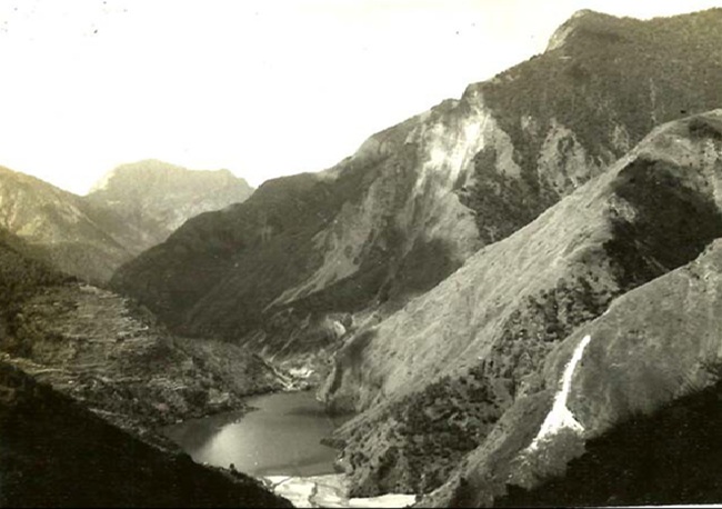
A view from Deldhunga showing the lake and on the backdrop, in the West, the Hariadeep hill (8500 ft) and opposite is the part of the Durmi hill (6000 ft.) and the right side of the lake, the Kitchmoli hill (7000 ft).

Another view from Deldhunga showing the mouth of the river Birehi with the silt deposit, and on the left, on the southern side, the fields and houses of Durmi village are seen.
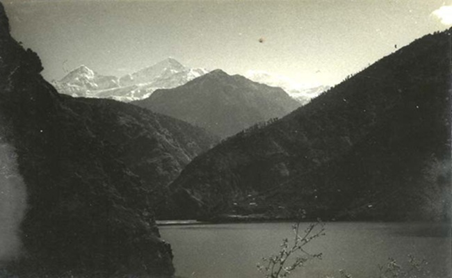
A view of the Gohna lake from the base of Kitchmoli hill showing in the backdrop the famous Kuari pass top and the three peaks of the Mt. Trisul.
A view of the lake from Kicthmoli hill, showing the FRH at the south-east of the lake.
The Introduction of Trout’s and boating in Gohna lake:
The boats were introduced in the lake, in 1893 to observe, the water levels of the lake and thus, successfully predict the bursting of the lake. Some time, in 1930 the trout fishes were introduced in Gohna lake, from Kashmir and where, they flourished like trouts of Kashmir. Trouts are not only the noblest sport but also provide food of highest quality, (Indian Forester, 1935). The trouts and boating, in Gohna became the common sports and recreational amusements for the British forest official families and which subsequently continued up to the time of the Indian forest officials and others, who visited Gohna lake. The best charm of the boating was to see Mt. Trisul, while boating and also to see its reflections in the lake.
The Great Catastrophic Blockage:
In the month of July 1970, during rainy season, there was heavy rainfall of about 24 inches (60.96 cm), in two days. in district Chamoli and its nearby places, All the tributaries of Alakhnanda were swollen and there were a number of landslides causing blockages, in these. There were two main blockage incident that occurred, almost simultaneously, i.), On 19th July on Gwaldom –Kuari road at Jhingi Patan, a mountain portion had fallen, in the upper reaches of Gohna lake and thus blocked the flow of river Birehi, in the up streams of the valley due to a cloud- burst. ii.). On 20th July, due to very heavy rains all over the upper reaches of district Chamoli, all the tributaries of Alakhnanda, mainly in Patalganga, a blockage was formed at Ringi village, and a lake was formed, one mile (1.6 km) ahead of Belakuchi. Unfortunately, on the late evening and in the night of July 20th both the blockages gave way and created a combined diastral havoc on the banks of river Alakhnanda and down below up to Haridwar.
i) The Belakuchi disaster:
The blockage Ringi village gave way at 7p.m. on 20th July 1970 resulting in a quick rise in the level of the river Alakhnanda. The water rose up to 15 meters above the riverbed. The abrupt abnormal rise of water engulfed a large number of vehicles, which were trapped on the road near Belakuchi. A few bridges were also swept away. It is recorded that 29 vehicles (17 tourist buses, 6 trucks, two military trucks and 6 taxis) along with 600 passengers, all of a sudden were washed away only at Belakuchi. It is also known as ‘Belakuchi disaster’.
ii) The Gohna disaster:
When blockage of the upper reaches of river Birehi burst out, a huge amount of water released rushed swiftly and the flow was so fast and heavy that on the first day, it filled up the lake Gohna entirely. On 20th July Shri N.D. Tewari, the then, Finance Minister to Govt. of India flew over the Gohna lake in a helicopter for an aerial survey; he described, the lake looked like a vast ocean and only the tops of the surrounding hills were seen. Possibly Mr. Tewari and the people of village Gohna (Durmi) were the only people to see the last sight of Lake Gohna. And, on the night of 20th July, the enormous pressure of the water burst out of the lake. A school and a dispensary at village Durmi (Gohna) were washed away. And, the worst hit place was Birehi, where all the fields, shops, houses, of the villagers, the Forest Log Cabin, the iron bridge, connecting Chamoli with Joshimath, etc., were completely washed away. The Gohna lake ceased to exist after 20th July 1970.
The combined disastrous losses of the 1970 Catastrophes: The final report of the Belkuchi and Gohna lake disaster as collected and compiled from the newspapers by the author is; about 1000 men and women lost their lives; about 1000 heads of cattle had been swept away; 10 suspension bridges and 6 motor iron bridges were also swept away; 210 houses were ravaged and 25 vehicles were washed away. The total loss was estimated at about 10 crores of rupees (in 1970).
In the year 2006, James Champion, who visited Gohna village, where once existed the Gohna Lake, remarked,
"There can be few lakes around the World with as short, but interesting, a history as the Gohna Lake, which lasted from 1893 until 1970, but during its short history, it nonetheless made its presence felt, both in the destruction it caused when the "dam" breached, and in the stirring story of the elaborate precautions that Lieut.-Colonel Pulford, Lieut. Crookshank and T H Holland took in setting up the warning system that enabled so many lives to be saved, (James Champion, 2008)
After Forty-four years:
A beautiful, serene lake of spectacular dimension, which had remained for 77 yrs., was lost forever to create a new geological and geographical history of the region. The present Google's satellite image, of 'Gohna lake, Uttarakhand' and some recent photographs clearly show that where, once existed the Gohna lake, it is now functioning like a narrow stream, and its bed has been filled up with big boulders and mud and silt. The area of the lake has become a pastoral expanse full of grass, crisscrossed with pretty small streams. The Birehi Ganga still continues to flow in the valley, as before 1893, and dominates the landscape. A suspension bridge has also been erected to cross the Birehi river to reach Durmi (Gohna) village, The bridge is clearly seen in Google satellite imagery.
Acknowledgement:
The author is thankful Dr. S. L. Kapoor, Retired Senior Scientist of NBRI, Lucknow for critically going through the manuscript and improving the text.
Suggested Readings:
1. Heim, A. and Ganseer, G. 1939. Central Himalaya, p. 51.
2. Champion, James. 2008. http://www.the-south-asian.com/April-June-2008/web-Gohna.
3. http://www.bl.uk/catalogues/indiaofficeselect/PhotoShowDescs.asp?CollID=84
4. Lt. Col .R.R. Pulford, Lt. Crookshank and T.H. Holland. (1894) A Narrative Report on the Gohna Lake and Flood, in November ,1894, Published by Govt. of United Provinces, Allahabad.
5. Imperial Gazetteer of India.vol.12; p.37.
6. Shah, N.C., Sarita, Dec.1969, (in Hindi).
7. Shah, N.C., Pioneer, August., 23, Magazine Section, p. I & II, 1970).
8. http://mappeditions.com/publications/a-royal-engineer-in-india
Images (taken in 1968) (c) Dr. N.C. Shah
08-Nov-2025
More by : Dr. N. C. Shah
