Jul 01, 2026
Jul 01, 2026
The survey carried out along the coastal tract from Visakhapatnam in the north to Machlipatnam in the south Andhra Pradesh coast brought out some interesting results. 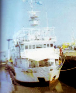 The resident of the eastern peninsular coast of India experienced devastation by the sea on 26 December, 2004 and a new term was added to their vocabulary. Tsunami before the day it occurred was hardly known to the people in India. A handful of students of geology and geography had heard about the term, but they could not envisage the fury of a tsunami. People at the Indian coast are used to disastrous storms, cyclones, tidal bores etc. Even for them tsunami was an unforgettable, dreaded experience.
In the east coast of Indian peninsula Tamilnadu coast was the worst affected. This was perhaps due to north-south situation of the coast, where the tsunami waves struck at perpendicular! Immediately after the tsunami the Marine Geology wing of the Geological Survey Of India (GSI) carried out a survey to assess the impact of the tsunami and also to ascertain causes of why the impact was more treacherous at one place than the other.
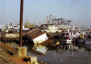
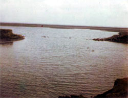
Tsunami waves hit the Indian coasts between 0845 hrs to 0930 hrs. At Visakhapatnam the coast as such remained unaffected. But the fishing harbour there is a closed basin. Tsunami waves 2.4 m high entered the harbour and kept it churning. The back and forth movement of the waves created piquant situation. GSI's ship was berthed at the harbour and at one stage it was almost grounded when the sea waters retreated. The repeated rise and fall created swirling current within the closed basin. These snapped the ropes that held the fishing boats. The tossing and turning of the boats overturned many of them. The sea waves snapped the ropes of the boats as if trying to free them from the shackles and many boats sank and vanished in the process. Thus loss at Visakhapatnam in terms of property was colossal.
 Dibbavanipalem, a small village south of Visakhapatnam escaped almost unscratched. Yet another village Revupolavaram with a rocky shore escaped the wrath of the tsunami. However the fishing boats at the harbour were not spared even here.
The coast at the Godavari River delta is convex and thus projects in to the Bay of Bengal. At Kakinada where the coast makes a northward notch a geographical feature called the Godavari Spit is formed. This area is prone to sea erosion and is under constant watch of the GSI. The erosion was heightened by the tsunami but fortunately there was no life of property. The coastal township perhaps escaped the destruction by the tsunami as it was sheltered by the Spit!
 Nilarevu River is an important distributary of the Godavari. At the confluence of Nilaveru river with the sea a village named Bhairavapalem is situated. This part of the Godavari delta has thick mangroves. These acted as a wonderful 'shock absorber' against the tsunami waves reports the GSI's survey. Mangroves with less than two metre height were bent landwards. It is postulated that erosion due to tsunami will retreat the shoreline further in this part. Sand dunes on the coast near the mouth of river Nilarevu acted as buffers against the onslaught of tsunami waves. However, in the process many of the dunes above the height of two metres were eroded. Similarly lagoons enclosed from three sides were also eroded by the swirling waters. Such sudden erosional processes do have an impact on the coast. Further southeast along the coast a beach dune complex which consisted of three rows of dunes spread over an area of 200 to 500 m saved the village Vasaltippa from the tsunami. The row of dunes closest to the sea was destroyed in the process.
 Vainateyam Godavari, yet another deltaic arm of the Godavari has an oil well. The cement concrete structure of the well was damaged by the gushing waters of the tsunami. The team of GSI noticed that the extent of damage had increased southwards. Mailavani Chinnalanka a tiny village on the coast west of Vainateyam Godavari was already facing constant erosion from the sea. During tsunami the village was obliterated and those who could not escape, perished. Only one sement mortar structure built as a cyclone shelter remained erect. The tsunami waves not only engulfed the village but also crossed over to other side and joined the Nali creek. Thus the village had become an island. In this part the tsunami did not spare even the sand dunes. Most of them were eroded leaving behind only rounded mounds.
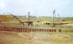
Andhra Pradesh Tourism Department had made a tourist resort at Manginapudi, near the ancient port town of Machilipatnam. The Bay of Bengal in this part is between the deltas of Godavari and Krishna Rivers. Thus this part forms a concave part of the coast. The damage here has been so severe that the tsunami completely razed the beach resort. A number of lives were lost and many other dwellings were also completely smashed. Worst part was that backwash of the waves created new channels within the adjacent park. The entire stretch of beach developed potholes due to scouring action of the waves.
 The coastal stretch further south of Machilipatnam near village Palle Tumalapalem has salt pans. In order to extract salt from the sea water bunds are made along the sea and sea water allowed to enter the enclosed areas. This water is allowed to evaporate in these pans and the left over salt is scrapped off. The fury of the waves was such that it tore open the bunds and salt pans merged with the sea.
The post tsunami scenario in the coasts presents a gloomy picture with cesspools of sea water along the shore. It becomes easy from here for the sea water to percolate down to the depths of the aquifers. Thus the scanty fresh water source is enriched with salinity, making it unfit for drinking. The sea water being heavier in density remains at the bottom making its removal impossible.
One lesson learnt from the detailed narrative is that the government should strictly impose the coastal zone safety mechanism. Habitations should not be permitted with 500 m distance of the shore. It is time that the areas with higher incidence of tsunami are mapped in detail and engineering or other measures taken to save the population from future tsunamis.
We have seen that tsunami impact was felt differently in different parts of the coast. Reasons were either the direction of the coast line vis-'-vis the direction of the waves, slope of the continental shelf, presence or absence of sand dunes and mangroves etc. Tsunami accentuated the erosion of the beaches. At places the expanse of the beach was enlarged whereas at others it was reduced considerably.
Since more than 25% population of the country lives along the coasts and since some of the best industrialized and developed hubs are along the coast, the government has to take up a detailed survey and protection measures as a long term preparation to meet the challenge of the tsunami.
We will read about the wrath of nature on the Gujarat coast and how several civilizations in the past thrived and perished there in the coming issues.
10-Feb-2007
More by : V. K. Joshi (Bijji)
