Jul 27, 2026
Jul 27, 2026
The 9.3 magnitude earthquake of 26th December 2004 in the Indian Ocean off the coast of northern Sumatra was the second amongst the strongest ever instrumentally recorded earthquakes. It triggered the most deadly tsunami in the history. The tsunami took a global toll of 2, 26,000 lives in 11 countries. In India the Andaman Nicobar islands being nearer to the epicenter were the worst hit. In the peninsular coastal tract the tsunami razed some areas and spared others. What perplexed the geologists was why the nature was biased against some areas? There were places completely ravaged whereas nearby areas escaped almost unhurt.
A survey was immediately taken up by the Geological Survey Of India (GSI) after the tsunami. It was found that in the mainland India along the coast, the tsunami impact was more severe along the Tamilnadu coast north of Palk Strait say A.R. Nambiar and the team of experts that surveyed the southwest coast.
The fury of tsunami waves on the coast bordering the Gulf of Mannar was less because of the buffering effect by the Sri Lankan landmass. The tsunami had struck the eastern coast, yet despite being on the western coast the South Kerala-West Tamilnadu coasts were stuck by the tsunami waves. The catastrophe there caused a considerable loss of life and property while they were struck by secondary waves diffracted from the eastern coast of Sri Lanka. These waves sort of wrapped around the tip of the Indian peninsula. This turning around did lessen the impact of the waves to some extent, but still certain pockets were badly mauled.
 The GSI's team found that damages on the southwest coast between Kanyakumari and Cochin were affected by the geographical, geomorphological and social factors. It was observed that the maximum destruction of life and properties on the west coast occurred in two sectors, i) between Kanyakumari and Kolachal in Tamilnadu and ii) in south Kerala, along a six kilometer stretch on either side of Kanyakumari estuary. The orientation of these parts of the coast is such that the tsunami waves struck there almost at right angles. The wave intensity gradually decreased northwards. At Manakkudi a few kilometers west of Kanayakumari where the beach elevation is very low with a wide and shallow estuary, the destruction was terrible. All the four spans of a newly constructed bridge across Manakkudi 'Kayal' were dislodged and thrown more than 70 metres upstream by the surging tsunami waves. At Manakkudi the waves were six metre high, whereas further north near Alapujha they were 1 to 1.5 m high.
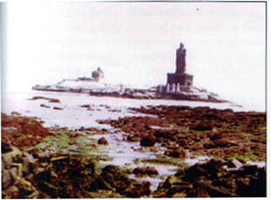 A unique phenomenon was noticed by the local people at Kanyakumari says the GSI's report. Prior to the arrival of the tsunami the sea receded by about 300 m, exposing rocky and muddy sea floor, as if trying to pay obeisance to the sacred place!
The waves hit Tamilnadu coast around 1100 hrs, whereas in Kerala sector the main waves arrived between 1230 hrs and 1430 hrs. In all probability the different patterns of damages caused in various sectors were due to different tsunami waves belonging to the same train of waves.
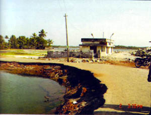
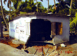
The shores shielded by landmass, cliffs and promontories were least affected by the giant tsunami waves. Thus places like Varkala, Quilon, Vizhinjam and Taingapatanam escaped the damages. Low lying estuarine beaches and barrier beaches were the worst affected, for example, Manakkudi, Andhakaranzahi and north and south Kanyakulam estuary. At Manakkudi rows of houses on the beach front were devastated and 700 people lost their lives. Low lying inland areas along estuaries were worst affected because the comparative height of the approaching wave increased as it entered the estuary/river mouth. At places like Kolachal the front row of houses on the beach front were damaged completely whereas, the rows behind escaped, because the wave energy was dissipated by then.
 In Kerala sector the narrow elongated beach between Kayamkulam 'kayal' on the east and the sea has a berm 1.5 m above the highest water level. Berm is therefore the highest point. Tsunami waves with a height of 2.5 m attacked the beach, spilled over the sea wall washing away everything in their wake and caused immense destruction of buildings. The sea water that gushed on the land eroded the land and left huge pits. Poorly constructed buildings in this area with low foundation depths were the worst affected when the gushing sea waves scoured the foundations away leading to building collapse. Poor fishermen who had built huts at the lowest levels on the beach were the worst sufferers.
The survey found that a sea wall is constructed along most thickly populated beaches of Kerala and Tamilnadu coast; Since the construction is unscientific it gets submerged even due to severe erosion by the monsoon waves. At places this wall did protect the people from waves that were 1 to 1.5 m high. But wherever the waves ran as three to four metres high the wall was of no use.
 When a tsunami wave approaches the shore two factors determine its intensity, they are, the topography of the adjacent seafloor and the shoreline configuration. In shallow waters the speed of the tsunami is reduced but the height of the wave's increases. Coastal areas where the inner shelf of the sea is steeper are less affected by the tsunami's wrath. South of Quilon the depth of the shelf suddenly increases from 5 to 40 m. Thus tsunami damage here has been much less. Compared to this in north Quilon where the slope of the shelf is very gentle and consequently damage was more.
Based on bathymetric analysis of the continental shelf (part of the continent that sloes in to the sea), the GSI's team found that wherever the shelf was gentler and wider the damage from tsunami was more. Such areas need special protection measures like construction of proper sea wall.
The giant tsunami waves bring lots of material from the depths of the sea and deposit it on the beach. After this tsunami too layers of lighter and finer quality of sand was were noticed by the geologists along the coast in many parts of Kerala. As opposed to this there are areas that are facing excessive erosion in the post tsunami phase. These areas are, Manakkudi, Melmidalam and Vizinjam. Tsunami also results in formation of beaches. Near Kayamkulam a 50 m wide beach made of very fine sand has been formed.
The detailed survey also reported that except coconut all other trees were affected by the sea water after they were inundated. In other words planting more coconut trees along the vulnerable coasts will help in controlling the wrath of future tsunamis.
Installing tsunami warning system is welcome. But what more is needed educating the masses about the perils of tsunami to dissuade them from settling down close to the sea front. Erection of civil engineering protection works like sea wall etc in a more scientific manner in consultation with the geologists will save many a lives.
03-Feb-2007
More by : V. K. Joshi (Bijji)
