Oct 24, 2026
Oct 24, 2026
by Sahithi B
How NASA and ISRO's NISAR Satellite Can See It
"Somewhere, something incredible is waiting to be known." — Carl Sagan, Astronomer and Science Communicator
Imagine waking up one morning to discover that the ground beneath your city has moved several centimeters. Roads begin to crack, buildings slowly tilt, and underground water pipes become damaged. Now imagine that a satellite hundreds of kilometers above Earth can detect this movement without even touching the ground. It sounds like science fiction, but it is becoming a reality.
The National Aeronautics and Space Administration (NASA) and the Indian Space Research Organisation (ISRO) have joined forces to develop an extraordinary satellite called NISAR (NASA-ISRO Synthetic Aperture Radar). Launched on July 30, 2025, NISAR is designed to monitor changes in Earth's land, ice, vegetation and other surface features.
Its advanced radar technology allows scientists to study the planet both day and night, even when clouds obstruct ordinary optical cameras.
In April 2026, NISAR demonstrated its capabilities by mapping how rapidly parts of Mexico City were sinking. This is more than a technological achievement. It shows how observations from space can help us understand problems occurring right beneath our feet.
1. Meet NISAR: A Satellite with Extraordinary Vision
"A satellite that doesn't just look at Earth—it measures how Earth changes."
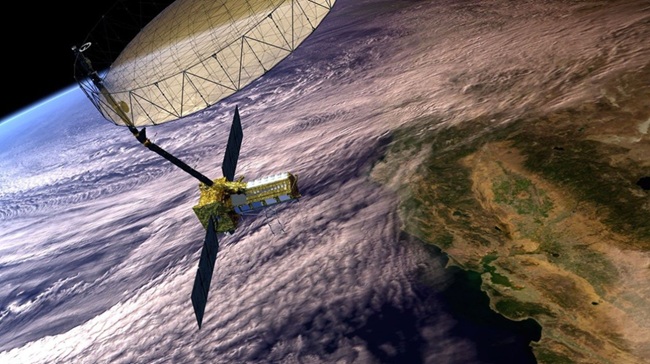
Image source - PIA26285.jpg
NISAR is a joint Earth-observation mission developed by NASA and ISRO. Its primary purpose is to measure and understand changes occurring across Earth's surface.
Unlike an ordinary camera satellite, NISAR uses Synthetic Aperture Radar (SAR) to observe the planet.
The mission carries two radar instruments operating at different wavelengths:
Together, these instruments allow scientists to study different characteristics of Earth's surface.
NISAR operates approximately 747 kilometers above Earth and is designed to observe nearly all the planet's land and ice-covered surfaces regularly.
Why Is This Important?
Earth is constantly changing. Glaciers move. Forests grow. Groundwater levels change. Tectonic forces deform the Earth's crust. Some changes are obvious, while others are so small that they are difficult to detect without specialized instruments.
NISAR helps scientists investigate these changes from space.
2. The Ground Beneath Us Is Never Truly Still
We usually imagine the ground as something solid and permanent. After all, roads, buildings and mountains appear stable to us. But Earth's surface is constantly moving, sometimes by tiny amounts and sometimes dramatically. There are several reasons for this movement:
Scientists call the gradual sinking of land subsidence. It can occur so slowly that people may not notice it until roads crack, buildings become damaged or drainage systems stop functioning properly. This is where NISAR becomes particularly useful.
By comparing radar observations collected at different times, scientists can measure changes in Earth's surface and identify regions that are rising or sinking.
3. Mexico City: The City That Is Sinking
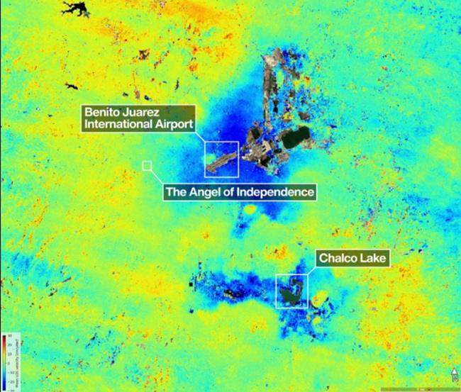
Image source - US-Indian Spacecraft Captures Mexico City Subsidence | NASA Jet Propulsion Laboratory (JPL)
One of the most striking examples of NISAR's capabilities comes from Mexico City.
In April 2026, NASA published findings based on NISAR observations showing that parts of Mexico City and its surroundings were sinking by more than two centimetres per month between October 25, 2025, and January 17, 2026.
The observations revealed particularly rapid sinking in certain areas, including near the city's international airport.
But why is this happening?
Mexico City was built over an ancient lakebed. Over many decades, extensive groundwater extraction and the weight of urban development have contributed to the compaction of the ground beneath the city. As underground water is removed, the soil and sediments can compress, causing the land above them to sink.
This is not a new problem. Parts of Mexico City have experienced serious subsidence for generations. However, NISAR offers a powerful way to monitor how the situation changes over time. Its observations can help scientists map areas experiencing rapid ground movement and investigate the potential consequences for infrastructure.
Why Should We Care?
Land subsidence can damage:
• Roads and highways
• Buildings and foundations
• Railway and metro systems
• Water pipelines
• Sewage infrastructure
The consequences can be expensive and dangerous, particularly in densely populated cities.
NISAR cannot stop land from sinking, but its observations can help researchers and authorities understand where the problem is occurring and how quickly it is progressing.
4. How Can a Satellite See Through Clouds?
This is one of the most fascinating parts of the mission.
Imagine trying to photograph a city during heavy rain. An ordinary optical satellite camera depends on sunlight reflected from Earth's surface. Thick clouds can obstruct that view, making it difficult to obtain a clear image of the ground.
NISAR works differently. Instead of relying on visible light, it transmits microwave radar signals towards Earth and measures the signals that return. These measurements contain information about the surface, including its roughness, structure and changes over time.
Because microwave radar can operate in darkness and through many weather conditions that obstruct optical observations, NISAR can collect useful measurements when conventional satellite imagery is limited. However, this does not mean radar can see through absolutely everything. Its performance depends on factors such as wavelength; the material being observed and the conditions on the ground.
An Everyday Analogy
Imagine trying to understand a room in complete darkness. A normal camera needs light to capture a conventional image. A radar system, by contrast, sends out a signal and analyses what returns. The two systems work differently, which is why radar can provide information that an ordinary camera cannot easily obtain.
5. The Science Behind Detecting Tiny Movements
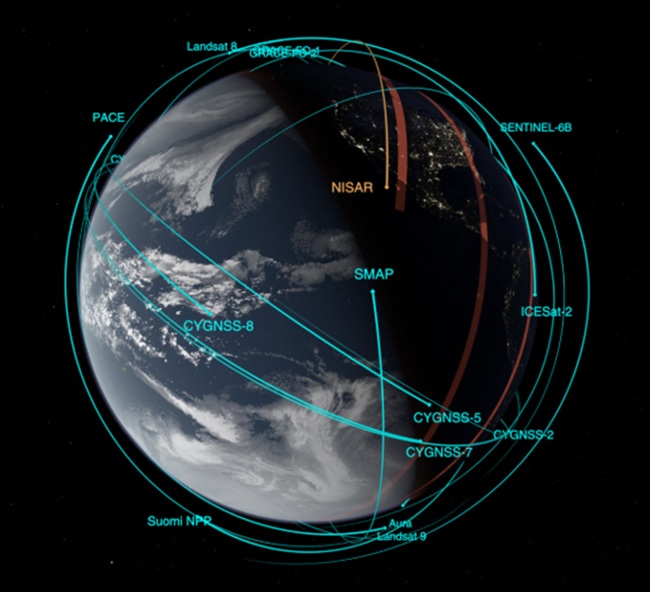
Image source - NASA SVS | NISAR satellite orbit
How can a satellite hundreds of kilometers above Earth measure such small changes in the ground?
One important technique is called Interferometric Synthetic Aperture Radar (InSAR). The principle involves comparing radar observations of the same area collected at different times. Radar waves have a property called phase, which describes where a wave is within its cycle. When scientists compare the phase information from two radar observations, they can detect changes in the distance between the satellite and the ground. These differences can reveal subtle surface movements.
For example, scientists may use this technique to investigate:
• Whether a region is sinking or rising
• How a volcanic area is deforming
• Whether a landslide is moving
• How the ground changes following an earthquake
The process requires careful analysis because changes in the atmosphere, vegetation and other factors can also affect the radar signal.
Scientists use specialized processing techniques to separate genuine ground movement from these other effects.
Why Is NISAR Special?
NISAR combines two radar systems operating at different wavelengths.
This allows researchers to study different characteristics of Earth's surface and obtain complementary measurements.
The mission is designed to provide a consistent, global view of changes in land and ice, supporting research into natural hazards and environmental processes.
6. From Earthquakes to Volcanoes: Monitoring a Changing Planet
Earthquakes and volcanic eruptions can change Earth's surface in dramatic ways. Before an earthquake, tectonic forces may cause gradual deformation. During and after an event, the ground can shift suddenly. Similarly, the movement of magma beneath a volcano can cause the surrounding land to rise or sink.
NISAR's radar observations can help scientists measure these changes. By comparing observations collected before and after an event, researchers can map how the ground has deformed. This information can improve our understanding of geological processes and help scientists assess the impacts of natural hazards. However, there is an important distinction: NISAR is not a crystal ball that can predict the exact time and location of an earthquake. Its value lies in observing surface changes, building scientific knowledge and supporting hazard assessment.
Why Does This Matter?
Better measurements can help researchers develop more accurate models of geological activity. They can also help authorities assess affected regions following disasters and understand how landscapes change over time.
7. Looking Beyond the Ground: Forests, Crops and Ice
NISAR's importance extends far beyond land subsidence. Its observations can also help scientists understand environmental changes across the planet.
Forests
Forests store carbon, support biodiversity and influence the global climate.
NISAR's radar measurements can help researchers study forest structure and changes in vegetation. The L-band radar is particularly useful because its longer wavelength can penetrate forest canopies to provide information about vegetation structure and the ground beneath.
Agriculture
Agricultural areas change throughout the growing season.
Radar observations can help scientists monitor vegetation and soil conditions, supporting research into agricultural productivity and land management. NISAR's complementary radar systems provide different types of information about vegetation and agricultural landscapes.
Glaciers and Ice Sheets
Glaciers and ice sheets are constantly moving.
NISAR can measure changes in ice surfaces and help scientists investigate how glaciers flow and how ice responds to environmental changes. These observations contribute to research on ice loss and its relationship to rising sea levels.
The Bigger Picture
The same satellite can help researchers investigate urban development, geological hazards and environmental change.
8. India's Role in a Global Scientific Achievement
NISAR is particularly significant for India because it represents a major collaboration between ISRO and NASA. The mission combines expertise and technology developed by both organizations.
NASA provided the L-band radar system and the large radar reflector antenna, while ISRO provided the S-band radar system and the spacecraft bus.
ISRO also launched the satellite from the Satish Dhawan Space Centre in Sriharikota, India.
The mission demonstrates how international scientific cooperation can combine different technologies to address shared challenges. Its data can benefit researchers and decisionmakers around the world, not just in the United States or India. This is particularly important because natural hazards and environmental changes do not respect national borders.
Earthquakes, melting glaciers, deforestation and changing water resources are global concerns. By making observations across large areas of the planet, NISAR can contribute to a broader scientific understanding of these challenges.
9. Where Space Science Meets Computer Science
There is another interesting side to NISAR: the enormous role of computing. A satellite collecting radar observations generates vast quantities of data. Those measurements must be processed, calibrated, analyzed and transformed into products that scientists can interpret. This is where computer science becomes essential.
Technologies such as the following can support Earth-observation research:
NISAR's data is being made available through NASA and ISRO data-distribution systems, creating opportunities for researchers to work with real satellite observations. For computer science students, this opens an exciting possibility. You don't necessarily need to become an astronaut to contribute to space exploration. You could develop algorithms that analyze satellite data, build machine-learning systems that identify environmental changes or create applications that turn scientific observations into useful information.
10. What Could the Future Look Like?
NISAR is designed to operate for an initial three-year science mission, during which it will repeatedly observe Earth's land and ice surfaces. As its data archive grows, researchers will have more observations to compare across seasons and years. That could help scientists investigate long-term changes in:
• Ground elevation
• Glacial movement
• Forest ecosystems
• Agricultural landscapes
• Soil moisture
• Geological deformation
The real value of the mission will emerge not from a single photograph, but from the patterns that become visible when observations are analyzed over time.
Imagine being able to compare radar measurements of a city across several months and identify areas where the ground is gradually sinking. Or studying a glacier over years to understand how its movement changes. Or observing how forests respond to environmental disturbances. These are the kinds of scientific questions that NISAR was designed to help investigate.
"The future of Earth observation isn't just about seeing our planet—it's about understanding how it changes."
Conclusion:
For most of human history, understanding the movement of Earth's surface required observations from the ground, specialized instruments and years of scientific investigation.
Today, a satellite orbiting hundreds of kilometers above us can measure subtle changes across vast regions of the planet.
The NASA–ISRO NISAR mission is helping scientists investigate land subsidence, geological deformation, vegetation changes and the movement of ice.
Its observations of Mexico City have demonstrated how radar measurements from space can reveal the scale and speed of a serious urban problem.
But the larger story goes beyond one city or one satellite. It is about learning to observe our planet more systematically and understanding the changes that affect the places where we live.
The ground beneath our feet may seem permanent, but Earth is a dynamic planet. Mountains rise. Glaciers move. Cities sink. Forests change. And somewhere above us, NISAR is collecting measurements that help scientists investigate these transformations.
A Final Thought
"The important thing is to never stop questioning." — Albert Einstein (widely attributed)
The more we question how our planet works, the more we discover how much remains to be understood. NISAR reminds us that scientific discovery doesn't always require travelling to another planet. Sometimes, it begins by looking more carefully at the one we already call home.
"The ground beneath us is moving. From space, science is helping us understand why."
References
24-Oct-2026
More by : Sahithi B